Környe
- Környe
-
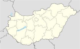
Környe est un village et une commune du comitat de Komárom-Esztergom en Hongrie.
Géographie
Cette section est vide, insuffisamment détaillée ou incomplète.
Votre aide est la bienvenue !
Histoire
Cette section est vide, insuffisamment détaillée ou incomplète.
Votre aide est la bienvenue !
Catégorie :
- Ville et village du comitat de Komárom-Esztergom
Wikimedia Foundation.
2010.
Contenu soumis à la licence CC-BY-SA. Source : Article Környe de Wikipédia en français (auteurs)
Regardez d'autres dictionnaires:
Környe — Infobox Settlement subdivision type = Country subdivision name = HUN timezone=CET utc offset=+1 timezone DST=CEST utc offset DST=+2|official name=Környe subdivision type1=County subdivision name1=Komárom Esztergom area total km2=45.35 population… … Wikipedia
Kornye — Original name in latin Krnye Name in other language Kornye, Krnye State code HU Continent/City Europe/Budapest longitude 47.54668 latitude 18.3208 altitude 164 Population 4359 Date 2012 05 06 … Cities with a population over 1000 database
Környe — Sp Kèrnė Ap Környe L Vengrija … Pasaulio vietovardžiai. Internetinė duomenų bazė
Oroszlány — Aerial view … Wikipedia
Mária Vadász — Personal information Full name Mária Vadász Born 1 January 1950(1950 01 01) Környe, Hungary Died 18 August 2009(2009 08 18) (aged 59) Bud … Wikipedia
faîtière — nf. (tuile courbe pour recouvrir le faîtage d un toit) : kornyé nm. (Saxel.002). A1) faîtière (lucarne pour éclairer l espace sous le comble) : kornyé nm. (002), tabatîre <tabatière> nf. (Albanais) … Dictionnaire Français-Savoyard
Komárom-Esztergom County — Infobox Hungarian county name =Komárom Esztergom region =Central Transdanubia seat = Tatabánya area = 2265 population = 319,000 density = 142 cities = 76Komárom Esztergom is the name of an administrative county (comitatus or megye) in northern… … Wikipedia
Tatabánya — Infobox Settlement image caption = County hall image shield = Tatabánya címere új.jpg subdivision type = Country subdivision name = HUN timezone=CET utc offset=+1 timezone DST=CEST utc offset DST=+2 pushpin pushpin label position = pushpin map… … Wikipedia
Hungarian State Railways — Magyar Államvasutak Zrt. Railway network An MAV Bombardier Talent waiting in Déli pályaudvar … Wikipedia
Dorog — Town … Wikipedia


 Hongrie
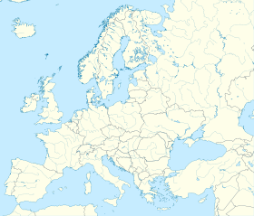

 Környe


