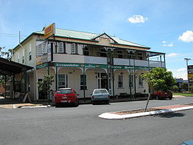
Nanango

Nanango

26° 40′ 00″ S 152° 00′ 00″ E / -26.666667, 152.000

Nanango
Hôtel à Nanango
Hôtel à Nanango
Administration
Pays Drapeau d'Australie Australie
État Queensland
Code postal QLD 4615
Maire David Ian Carter
Région de Burnett Sud
Géographie
Coordonnées 26° 40′ 00″ Sud
       152° 00′ 00″ Est
/ -26.666667, 152
Altitude 442 m
Démographie
Population 3 183 hab. (2006)
Localisation

  Géolocalisation sur la carte : Queensland
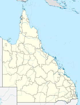
Voir sur la carte : Queensland
City locator 14.svg
Nanango

  Géolocalisation sur la carte : Australie
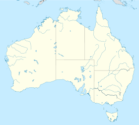
Voir sur la carte : Australie
City locator 14.svg
Nanango

Nanango (3 183 habitants) est une ville du sud-est du Queensland, en Australie à 201 kilomètres au nord-ouest de Brisbane à l'intersection de la D'Aguilar Highway avec la Burnett Highway

Le nom de la ville est d'origine aborigène mais son sens n'est pas connu.

Son économie repose sur les mines de charbon, l'agriculture (élevage de bovins et de porcs) et l'exploitation de la forêt.

Référence


Wikimedia Foundation. 2010.

Contenu soumis à la licence CC-BY-SA. Source : Article Nanango de Wikipédia en français (auteurs)

Игры ⚽ Поможем написать курсовую

Regardez d'autres dictionnaires:

  • Nanango, Queensland — Nanango redirects here. For the Queensland electoral division, see Electoral district of Nanango. Nanango Queensland Drayton St, the main street of Nanango …   Wikipedia

  • Nanango Antler Motel — (Nanango,Австралия) Категория отеля …   Каталог отелей

  • Nanango railway line — Nanango Branch Railway, Queensland, Australia. On 31 October 1882, parliament approved the construction of a branch line from Theebine (then called Kilkivan Junction) west to Kilkivan after gold and copper were discovered in this region of… …   Wikipedia

  • Nanango Fitzroy Motel — (Nanango,Австралия) Категория отеля: 3,5 звезд Адрес: 55 Fitzroy Street, 4615 …   Каталог отелей

  • Nanango — /nəˈnæŋgoʊ/ (say nuh nanggoh) noun a town in south eastern Qld, near Kingaroy; site of a power station and coal mine …  

  • Shire of Nanango — Queensland Location within Queensland Population: 9,049(2006 census) …   Wikipedia

  • Electoral district of Nanango — The division of Nanango is an electoral division in the state of Queensland, Australia.The Division contains the towns of * Nanango * Esk * Kingaroy * Blackbutt * Brooklands * Coominya * Inverlaw * Jimna * Kilcoy * Linville * Kumbia * Maidenwell… …   Wikipedia

  • Comté de Nanango — 26°40′14.3″S 151°59′59.9″E / 26.670639, 151.999972 …   Wikipédia en Français

  • D'Aguilar Highway — D Aguilar Highway …   Wikipedia

  • Brisbane Ladies — is an Australian folksong and is one of many adaptations of Spanish Ladies. The version given below is the most commonly sung, but the original mentions Nanango favorably as that jolly old township .HistoryThe song dates back to at least the 1880 …   Wikipedia

Share the article and excerpts

Direct link
Do a right-click on the link above
and select “Copy Link”