Piangil
Contenu soumis à la licence CC-BY-SA. Source : Article Piangil de Wikipédia en français (auteurs)
Regardez d'autres dictionnaires:
Piangil, Victoria — Infobox Australian Place | type = town name = Piangil state = vic caption = lga = Rural City of Swan Hill postcode = 3597 est = pop = 654 elevation= maxtemp = mintemp = rainfall = stategov = Swan Hill fedgov = Mallee dist1 = 382 dir1 = NW… … Wikipedia
Mallee Highway — Formerly … Wikipedia
Swan Hill railway line, Victoria — VictorianRailwayLineInfobox type = vic name = Swan Hill yearcommenced = yearopened = yearcompleted = yearclosed = fate = lengthkm = stations = tracks = 1 users = servicepattern = RollingStock = connections = formerconnections = The Swan Hill line … Wikipedia
Nyah West, Victoria — Nyah West Victoria … Wikipedia
List of localities in Victoria (Australia) — Map of Local Government Areas in Victoria This is a list of locality names and populated place names in the state of Victoria, Australia, outside the Melbourne metropolitan area. It is organised by region from the south west of the state to the… … Wikipedia
Mallee Highway — mit eine … Deutsch Wikipedia
Murray Valley Highway — Murray Valley Highway … Wikipedia
Manangatang, Victoria — Manangatang Victoria … Wikipedia
Woorinen South, Victoria — Infobox Australian Place | type = town name = Woorinen South state = vic caption = lga = Rural City of Swan Hill postcode = 3588 est = pop = 315 elevation= 70 maxtemp = mintemp = rainfall = stategov = Swan Hill fedgov = Mallee dist1 = 350 dir1 =… … Wikipedia
Nyah, Victoria — Nyah Victoria … Wikipedia
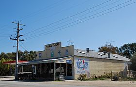 le magasin général de Piangil
 Australie

