Pinnaroo
Contenu soumis à la licence CC-BY-SA. Source : Article Pinnaroo de Wikipédia en français (auteurs)
Regardez d'autres dictionnaires:
Pinnaroo, South Australia — Infobox Australian Place | type = town name = Pinnaroo state = sa caption = Location of Pinnaroo in South Australia (red) lga = Southern Mallee District Council postcode = 5304 est = 1904 [cite web |url=http://www.placenames.sa.gov.au/pno/pnores.p… … Wikipedia
Mallee Football League (South Australia) — Mallee Football League General information Founded 1994 Current clubs Border Downs Tintinara FC, Karoonda FC, Lameroo FC, Murrayville FC, Peake FC, Pinnaroo FC Former clubs Ngallo FC … Wikipedia
Mallee Highway — Formerly … Wikipedia
Mallee Highway — mit eine … Deutsch Wikipedia
Mallee Football League — The Mallee Football League (MFL) is an Australian rules football competition in South Australia. The League comprises teams located in south eastern South Australia and one team (Murrayville) located in western Victoria. The Mallee Football… … Wikipedia
Rail transport in South Australia — South Australia was the first colony in Australia to build a railway line. It was a horse drawn tramway from the port of Goolwa on the Murray River to an ocean harbour at Port Elliot in 1854. Today the state has RailGauge|1600 broad gauge… … Wikipedia
Ouyen railway station, Victoria — VictorianClosedRailwayStation NAME=Ouyen LINE=Mildura DISTANCE=467.75 km PLATFORMS= 1 TRACKS= 1 STATUS=Closed OPENED=1903 CLOSED=1993 http://maps.google.com/maps?f=q hl=en q=Ouyen+Station,+Victoria,+Australia sll= 35.982873,142.920841… … Wikipedia
Mildura railway line — Mildura railway line, Victoria Line details Commenced 1874 Completed 1903 Closed … Wikipedia
Ouyen railway station — Ouyen Station information Line Mildura Distance from Southern Cross 467.75 km Number of platforms 1 Number of tracks 1 Station status … Wikipedia
Southern Mallee District Council — South Australia The position of Southern Mallee District Council in SA. Populatio … Wikipedia
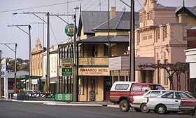 La grand'rue de Pinnaroo
 Australie
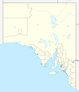
 Pinnaroo