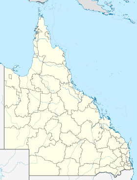
Rubyvale
Contenu soumis à la licence CC-BY-SA. Source : Article Rubyvale de Wikipédia en français (auteurs)
Regardez d'autres dictionnaires:
Rubyvale Motel & Holiday Units — (Rubyvale,Австралия) Категория отеля: 4 звездочный отель Адрес: 35 He … Каталог отелей
Rubyvale, Queensland — Rubyvale is a town in the Australian state of Queensland, approximately 80 km west of Emerald. Situated in a region called the Gemfields, sapphires are mined extensively in the area.Rubyvale is home to a small library, a convenience store/news… … Wikipedia
The Gemfields — is a region in central western Queensland in Australia, near the town of Emerald.As the name suggests, the main industry in the Gemfields is sapphire mining, supported by tourism.The region contains four small towns: Anakie, Rubyvale, Sapphire,… … Wikipedia
Sapphire, Queensland — Sapphire Queensland … Wikipedia
Emerald, Queensland — Infobox Australian Place | type = town name = Emerald state = qld caption = Location of Emerald in Queensland (red) lga = Central Highlands Regional Council postcode = 4720 est = pop = 15,500 elevation= 189 maxtemp = 29.9 mintemp = 16.4 rainfall … Wikipedia
Duaringa, Queensland — Duaringa Queensland … Wikipedia
Tieri, Queensland — Tieri Queensland … Wikipedia
Shire of Emerald — Infobox Australian Place | type = lga name = Shire of Emerald state = qld imagesize= 180 caption = Location within Queensland pop = 14,161 area = est = seat = Emerald region = Central Highlands logosize = 103 url = http://www.emerald.qld.gov.au/… … Wikipedia
Herbert's Rock-wallaby — Taxobox name = Herbert s Rock wallabyMSW3 Groves|pages=67] status = LC status system = iucn3.1 status ref = IUCN2006|assessors=Australasian Marsupial Monotreme Specialist Group|year=1996|id=41515|title=Petrogale herberti|downloaded=2007 01 28 ]… … Wikipedia
Central Highlands Regional Council — is a Local Government Area in Queensland, Australia. The Local Government Area was created in March 2008 as a result of the report of the Local Government Reform Commission released in July 2007. The new Council, located in Central Queensland,… … Wikipedia
 La grand-rue de Rubyvale
 Australie
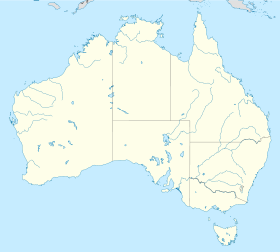
 Rubyvale