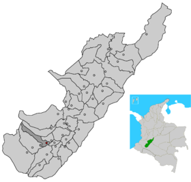
Saladoblanco
- Saladoblanco
-
Catégories :
- Ville de Colombie
- Municipalité de Huila (Colombie)
Wikimedia Foundation.
2010.
Contenu soumis à la licence CC-BY-SA. Source : Article Saladoblanco de Wikipédia en français (auteurs)
Regardez d'autres dictionnaires:
Saladoblanco — is a town and municipality in the Huila Department, Colombia … Wikipedia
Saladoblanco — Original name in latin Saladoblanco Name in other language Saladoblanco State code CO Continent/City America/Bogota longitude 1.99244 latitude 76.04335 altitude 1489 Population 1662 Date 2012 01 19 … Cities with a population over 1000 database
Saladoblanco — Admin ASC 2 Code Orig. name Saladoblanco Country and Admin Code CO.16.3670384 CO … World countries Adminstrative division ASC I-II
Serranía de Minas Fauna and Flora Sanctuary — located near the Purace National Park in the Department of Huila, the Serranía de Minas is part of the fluvial star of Magdalena, where most of the Magdalena river affluents are born.La Serranía de Minas is located within the Cordillera Central… … Wikipedia
Huila Department — For other uses, see Huila (disambiguation). Department of Huila Departamento del Huila Department … Wikipedia
Municipalities of Colombia — The Municipalities of Colombia are decentralized subdivisions of the Republic of Colombia. Municipalities make up most of the departments of Colombia with 1,119 municipalities (municipios). Each one of them is led by a Mayor (Alcalde) elected by… … Wikipedia
Colombia, Huila — For other uses, see Colombia (disambiguation). Colombia, Huila Municipality and town … Wikipedia
Nataga — Municipality and town Location of the municipality and town of Nataga in the Huila Department of Colombia. Country … Wikipedia
Oporapa — Municipality and town Location of the municipality and town of Oporapa in the Huila Department of Colombia. Countr … Wikipedia
Liste der Gemeinden in Huila (Kolumbien) — Das Departamento de Huila besteht aus 37 Gemeinden (Municipios). Diese untergliedern sich in einen Gemeindekern (Cabecera Municipal) und dem Umland (Resto Rural). Das Umland wiederum wird weiter unterteilt in sogenannte Polizeiinspektionen… … Deutsch Wikipedia


 Colombie
 Huila
Huila