Settecamini
- Settecamini
-
41° 56′ N 12° 38′ E / 41.94, 12.63

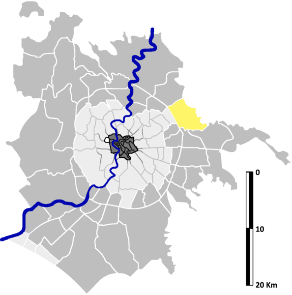
Localisation de Settecamini sur la carte administrative de
Rome.
Settecamini est une zona di Roma (zone de Rome) située au nord-est de Rome dans l'Agro Romano en Italie. Elle est désignée dans la nomenclature administrative par Z.VI et fait partie du Municipio V. Sa population est de 20 626 habitants[1] répartis sur une superficie de 21,61 km².
Géographie
Cette section est vide, insuffisamment détaillée ou incomplète.
Votre aide est la bienvenue !
Histoire
Cette section est vide, insuffisamment détaillée ou incomplète.
Votre aide est la bienvenue !
L'essentiel de cette zone est historiquement située sur la propriété du duc Leopoldo Torlonia.
Lieux particuliers
- Église Santa Maria dell'Olivo (1926)
- Église San Michele
- Église Sant'Alessio (!982)
Notes et références
- ↑ Statistiques officielles de la commune de Rome au 31 décembre 2009.
Wikimedia Foundation.
2010.
Contenu soumis à la licence CC-BY-SA. Source : Article Settecamini de Wikipédia en français (auteurs)
Regardez d'autres dictionnaires:
Settecamini — is a quarter of Rome, and is the name of the sixth area of the town of Rome in the Agro Romano indicated by Z. VI. It is located in the east of the town near the Grande Raccordo Anulare (Italian for the Greater Ring Junction ) and it borders the… … Wikipedia
Locanda Settecamini — (Campello sul Clitunno,Италия) Категория отеля: Адрес: Viale Settecamini 18, 06 … Каталог отелей
Subdivisions administratives de Rome — Les 1 285 km² du territoire de la commune de Rome est divisé selon 3 formes : Une organisation administrative Une organisation urbanistique Une organisation toponymique Sommaire 1 Organisation administrative 2 Organisation urbanistique… … Wikipédia en Français
Administrative subdivision of Rome — The administrative subdivision of Rome consists of the 19 sub municipalities (municipi) of Rome s municipality. Originally, the city was divided into 20 sub municipalities, but the XIV, what is now the Comune di Fiumicino, voted some years ago to … Wikipedia
Tiburtina — Das V. Munizipium Tiburtina ist eines der 19 Munizipien der Stadt Rom. Es liegt östlich der Altstadt und erstreckt sich in etwa zwischen der Via Nomentana und der A24 Strada dei Parchi. Tiburtina hat 178.660 Einwohner (2006). Es teilt sich in… … Deutsch Wikipedia
Municipi de Rome — Carte des 19 Municipi de Rome Les dix neuf Municipio de Rome représentent l administration locale de la capitale italienne en application des objectifs de décentralisation des pouvoirs établis pour loi italienne. Ceux ci prennent la place des… … Wikipédia en Français
Municipio V — 41° 56′ 00″ N 12° 35′ 56″ E / 41.9333, 12.5989 … Wikipédia en Français
Симфороза из Тиволи — Симфороза (Symphorosa, Simforosa, Sinforosa, ум. ок. 138) раннехристианская мученица из Тиволи, память совершается 18 июля. По преданию, вдова св. Гетулия, она была умучена во времена императора Адриана вместе с семью своими сыновьями в… … Википедия
Zones de Rome — Carte des 59 zone de Rome (en gris foncé à l extérieur) Les zones de Rome de l Agro Romano (en italien zone di Roma dell Agro Romano) constituent le quatrième et dernier niveau de subdivisions administratives de Rome. Elles correspondent aux… … Wikipédia en Français
Symphorosa — Infobox Saint name= Saint Symphorosa birth date= death date= 138 AD feast day= 18 July venerated in= Roman Catholic Church imagesize= 250px caption= birth place= death place= titles=Martyr beatified date= beatified place= beatified by= canonized… … Wikipedia