Standedge
- Standedge
-

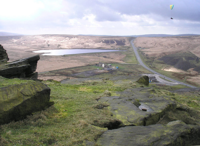
Standedge vu depuis Pule Hill. On aperçoit l'A62 qui traverse cette région.
Standedge est une zone de landes de la chaîne des Pennines au nord-ouest de l'Angleterre. Située entre Marsden et Diggle, appartenant respectivement aux comtés du Yorkshire de l'Ouest et du Grand Manchester, Standedge est un carrefour routier majeur depuis l'époque romaine, voire plus tôt.
Wikimedia Foundation.
2010.
Contenu soumis à la licence CC-BY-SA. Source : Article Standedge de Wikipédia en français (auteurs)
Regardez d'autres dictionnaires:
Standedge — Location map|United Kingdom label = background = white lat = 53.583196 long = 1.969031 caption = Map showing the location of Standedge in the United Kingdom float = right width = 185Standedge (normally pronounced Stannige ) is a moorland… … Wikipedia
Standedge Tunnels — Location map|United Kingdom label = background = white lat = 53.591283 long = 1.95996 caption = Map showing the location of the Standedge Tunnels in the United Kingdom float = right width = 185The Standedge Tunnels (Standedge is normally… … Wikipedia
Marsden, West Yorkshire — Coordinates: 53°36′04″N 1°55′36″W / 53.6011°N 1.9267°W / 53.6011; 1.9267 … Wikipedia
Huddersfield Narrow Canal — The Huddersfield Narrow Canal is an inland waterway in northern England. It runs just under 20 miles (35 km) from the junction with the Huddersfield Broad Canal near Aspley Basin at Huddersfield to the junction with the Ashton Canal at Whitelands … Wikipedia
Castleshaw Roman fort — Infobox Historic building caption=A ditch of Castleshaw Roman fort name=Castleshaw Roman fort location town=Castleshaw Saddleworth Greater Manchester location country=England map type=Greater Manchester latitude=53.583245 longitude= 2.001737… … Wikipedia
Fuerte romano de Castleshaw — Foso del fuerte roma … Wikipedia Español
Micklehurst Line — The Micklehurst Line was a railway line between Stalybridge, Cheshire, and Diggle junction in the West Riding of Yorkshire. The line, approximately eight miles long, was also sometimes referred to as the Micklehurst Loop and the Stalybridge and… … Wikipedia
Colne Valley — For the constituency of this name, see Colne Valley (UK Parliament constituency). The Colne Valley is a steep sided valley on the east flank of the Pennine Hills in the English county of West Yorkshire. It takes its name from the River Colne… … Wikipedia
Huddersfield Line — The Huddersfield Line is the name given to one of the busiest rail services on the West Yorkshire MetroTrain network in northern England. Local services are operated by Northern Rail with longer distance services operated by TransPennine Express … Wikipedia
Sapperton Canal Tunnel — The Coates Portal at the south eastern end of the Sapperton Canal Tunnel Overview Location Sapperton, Gloucestershire Coordinates … Wikipedia