Starý Tekov
- Starý Tekov
-
Starý Tekov (allemand : Altbarsch , hongrois : Óbars)[4] est un village de Slovaquie situé dans la région de Nitra.
Histoire
Première mention écrite du village en 1075.
Notes et références
Catégories :
- Village de Slovaquie
- Village et ville du district de Levice
Wikimedia Foundation.
2010.
Contenu soumis à la licence CC-BY-SA. Source : Article Starý Tekov de Wikipédia en français (auteurs)
Regardez d'autres dictionnaires:
Starý Tekov — Wappen Karte … Deutsch Wikipedia
Starý Tekov — ( de. Teckoff, hu. Óbars) is a village and municipality in the Levice District in the Nitra Region of Slovakia.HistoryIn historical records the village was first mentioned in 1075.GeographyThe village lies at an altitude of 176 metres and covers… … Wikipedia
Starý Hrádok — (Village) Administration Pays Slovaquie … Wikipédia en Français
Stary — may refer to:* Stary Oskol * Stary Dwór * Stary Górnik * Stary Wiązów * Stary Wołów * Stary Henryków * Stary Węgliniec * Stary Jaworów * Stary Śleszów * Stary Zawidów * Gmina Stary Sącz * Stary Sącz * Gmina Stary Dzików * Stary Gostyń * Stary… … Wikipedia
Nový Tekov — Coordinates: 48°15′N 18°31′E / 48.25°N 18.517°E / 48.25; 18.517 … Wikipedia
Nový Tekov — (Village) Administration Pays Slovaquie … Wikipédia en Français
Liste deutscher Bezeichnungen slowakischer Orte — In dieser Liste werden slowakischen Orten (Städte, Flüsse, Gebirge, etc.) deren deutsche Bezeichnungen gegenübergestellt, die sie aus deutschsprachiger Sicht heute noch tragen oder zu Zeiten trugen, als die Gebiete zur Donaumonarchie gehörten.… … Deutsch Wikipedia
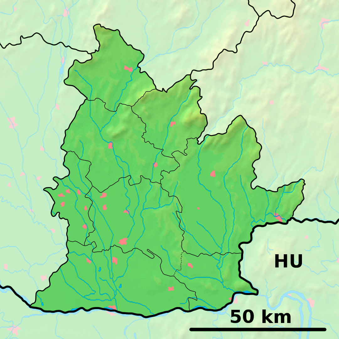
District de Levice — Levice Informations Pays … Wikipédia en Français
Gran (Fluss) — Dieser Artikel beschreibt den Fluss Hron. Für den gleichnamigen tschechischen Agrarwissenschaftler; siehe Jan Hron. Vorlage:Infobox Fluss/DGWK fehltVorlage:Infobox Fluss/EINZUGSGEBIET fehltVorlage:Infobox Fluss/ABFLUSS fehltVorlage:Infobox… … Deutsch Wikipedia
History of Slovakia — This article discusses the history of the territory of Slovakia. Prehistory Palaeolithic Radiocarbon dating puts the oldest surviving archaeological artifacts from Slovakia found near Nové Mesto nad Váhom at 270,000 BCE, in the Early Paleolithic… … Wikipedia
 Slovaquie
 Starý Tekov