Biggekerke
Contenu soumis à la licence CC-BY-SA. Source : Article Biggekerke de Wikipédia en français (auteurs)
Regardez d'autres dictionnaires:
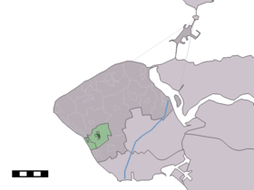
Biggekerke — Dutch town locator maps mun town caption = The town centre (dark green) and the statistical district (light green) of Biggekerke in the municipality of Veere.Biggekerke (coord|51|30|N|3|32|E|type:city(602)) is a town in the Dutch province of… … Wikipedia
De Tollenaer — (Biggekerke,Нидерланды) Категория отеля: Адрес: 4373 RC Biggekerke, Нидерланды … Каталог отелей
Vakantieverblijf Uit en Thuis — (Biggekerke,Нидерланды) Категория отеля: Адрес: Dorpsstraat 53, 4373 AB Biggek … Каталог отелей
Motas castrales en Zelanda — En la provincia de Zelanda, en Países Bajos, se ha descubierto un gran número de motas castrales, pequeños asentamientos defensivos situados sobre afloramientos o colinas de escasa elevación. Esta tipología de castillos tuvo un importante… … Wikipedia Español
Strandcamping Valkenisse — (Biggekerke,Нидерланды) Категория отеля: Адрес: Valkenisseweg 64, 4373 RR … Каталог отелей
Koudekerke — 51°28′51″N 3°33′10″E / 51.48083, 3.55278 … Wikipédia en Français
Veere (commune) — Pour les articles homonymes, voir Veere. Veere … Wikipédia en Français
Zoutelande — 51°30′4″N 3°29′12″E / 51.50111, 3.48667 … Wikipédia en Français
Veere — Infobox Settlement official name = Veere flag size = 120x100px image shield = Coat of arms of Veere.png shield size = 120x100px mapsize = 280px subdivision type = Country subdivision name = Netherlands subdivision type1 = Province subdivision… … Wikipedia
Kinderdijk — Coordinates: 51°53′N 4°38′E / 51.883°N 4.633°E / 51.883; 4.633 … Wikipedia
 Pays-Bas