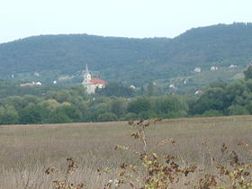
Szentbékkálla
- Szentbékkálla
-
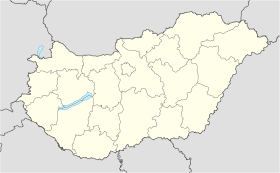
Szentbékkálla est un village et une commune du comitat de Veszprém en Hongrie.
Géographie
Cette section est vide, insuffisamment détaillée ou incomplète.
Votre aide est la bienvenue !
Histoire
Cette section est vide, insuffisamment détaillée ou incomplète.
Votre aide est la bienvenue !
Catégorie :
- Ville et village du comitat de Veszprém
Wikimedia Foundation.
2010.
Contenu soumis à la licence CC-BY-SA. Source : Article Szentbékkálla de Wikipédia en français (auteurs)
Regardez d'autres dictionnaires:
Szentbékkálla — is a village in the Káli basin, Balaton Highland, Hungary. In the medieval ages the village had a monastery of St. Benedict order, that explains its name, because earlier it was Szentbenedekkál (Kál of Saint Benedict). Kál was a prince and… … Wikipedia
Hunveyor Husar planetary analog field trips — The Hunveyor (Hungarian UNiversity SURVEYOR) and Husar rover (Hungarian University Surface Analyser Rover) acronyms mark the educational planetary robot system of the Hungarian universities, colleges, high schools. Such systems are built by… … Wikipedia
Veszprém (county) — Infobox Hungarian county name =Veszprém region =Central Transdanubia seat = Veszprém area = 4613 population = 375,000 density = 81 cities = 217: For the historical county see Veszprém (former county). Veszprém (in Slovak Vesprím ) is the name of… … Wikipedia
Devecser — Aerial photography: Devecser Palace … Wikipedia
Countrywide Blue Tour in Hungary — The route of the Countrywide Blue Tour in Hungary The Countrywide Blue Tour (in Hungarian: Országos Kéktúra, Kéktúra or simply OKT) is a part of the Hungarian section of the European Long Distance Walking Route E4. The route starts atop the… … Wikipedia
Kleingebiet Tapolca — Das Kleingebiet Tapolca (ungarisch Tapolcai kistérség) ist eine ungarische Verwaltungseinheit (LAU 1) innerhalb des Komitat Tapolca in Ungarn. Der Verwaltungssitz ist Tapolca. Ortschaften Die folgenden Ortschaften gehören zum Kleingebiet Tapolca … Deutsch Wikipedia
Ajka — Héraldique Administration … Wikipédia en Français
Balatonfüred — Héraldique … Wikipédia en Français
Csesznek — Héraldique Administration … Wikipédia en Français
Halimba — Héraldique … Wikipédia en Français

 Hongrie

 Szentbékkálla


