Thanet
Contenu soumis à la licence CC-BY-SA. Source : Article Thanet de Wikipédia en français (auteurs)
Regardez d'autres dictionnaires:
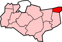
Thanet — is a local government district of Kent, England [ [http://www.thanet.gov.uk/ Thanet District website] ] which was formed under the Local Government Act 1972, and came into being on 1 April 1974. The Isle of Thanet makes up the major part of the… … Wikipedia
Thanet — hat folgende Bedeutungen: eine Landschaft in der englischen Grafschaft Kent, siehe Isle of Thanet ein Verwaltungsbezirk im Südosten Englands, siehe Thanet (District) ein Zeitintervall der Erdgeschichte, siehe Thanetium Di … Deutsch Wikipedia
Thanet — (spr. Dhännet), Insel an der Mündung des Stour, zur englischen Grafschaft Kent gehörig, 8 Meilen lang, 4 breit; Producte: Getreide, Färberröthe, Feigenbäume (sollen aus der Römerzeit stammen); Vorgebirge: Northforeland; auf ihr die Städte:… … Pierer's Universal-Lexikon
Thanet — (spr. tähnnĕt), zur engl. Grafsch. Kent gehörige Insel, nur durch einen Flußarm vom Festlande getrennt, mit dem Kap North Foreland … Kleines Konversations-Lexikon
Thanet — (Stännet), engl. Insel an der Mündung des Stour, wohlangebaut und fruchtbar, mit 31000 E.; 449 n. Chr. Landungsplatz der Angelsachsen … Herders Conversations-Lexikon
Thanet — Distrito de Thanet mostrado al interior de Kent Thanet es un distrito no metropolitano de Kent, condado de Inglaterra, que fue formado bajo la Ley de Gobierno Local de 1972 a partir del 1 de abril de 1974. Ocupa el área conocida como la isla de… … Wikipedia Español
Thanet — /than it/, n. 1. Octave /ok tiv, tayv/, pen name of Alice French. 2. Isle of, an island in SE England, forming the NE tip of Kent county. 42 sq. mi. (109 sq. km). * * * ▪ district, England, United Kingdom district, administrative and… … Universalium
Thanet District Council — is the local government body for the Thanet district [ [http://www.thanet.gov.uk/ Thanet District Council] ] [ [http://www.thanet.gov.uk/services/a to z of services.aspx A Z of Thanet District Council services] ] . Its administrative centre is… … Wikipedia
Thanet College — is a further education college located on the Isle of Thanet in Broadstairs, Kent on the southeast coast of the United Kingdom.The main campus is located on Ramsgate Road, Broadstairs. Plans however are to relocate the college into purpose built… … Wikipedia
Thanet (distrito) — Saltar a navegación, búsqueda Thanet es un distrito no metropolitano de Kent, condado de Inglaterra, que fue formado bajo la Acta de Gobierno Local de 1972 a partir del 1 de abril de 1974. Ocupa el área conocida como la isla de Thanet y es… … Wikipedia Español