Udot
Contenu soumis à la licence CC-BY-SA. Source : Article Udot de Wikipédia en français (auteurs)
Regardez d'autres dictionnaires:
Udot — or UDOT may refer to the following: *The island of Udot in the Federated States of Micronesia *Utah Department of Transportation in Utah, United States of America … Wikipedia
Udot, Federated States of Micronesia — Udot is a heavily wooded minor island and municipality in Truk Lagoon, Chuuk State, the Federated States of Micronesia. The island measures 4 by 2.6 km (2.5 by 1.6 miles) [Google Earth measurements] and the population numbers 1774 (2000 FSM… … Wikipedia
Udot-Fonuweisom Municipality — Admin ASC 2 Code Orig. name Udot Fonuweisom Municipality Country and Admin Code FM.03.UD FM … World countries Adminstrative division ASC I-II
UDOT — abbr. Utah Department Of Transportation … Dictionary of abbreviations
List of state highways serving Utah state parks and institutions — infobox road state=UT previous type=SR previous route=280 next type=US next route=491In the U.S. state of Utah, some state highways have been specifically designated to serve state parks and state institutions. The range of numbers from State… … Wikipedia
U.S. Route 191 in Utah — Infobox road state=UT type=US route=191 section=125 maint=UDOT length mi=404.168 length round=3 length ref=Utah Department of Transportation, [http://www.udot.utah.gov/main/f?p=100:pg:7362807272423840:::1:T,V:814, Highway Reference Information] … Wikipedia
Utah State Route 30 — Infobox road state=UT type=SR route=30 alternate name=Bear Lake Scenic Byway Valley View Highway section=108 maint= length mi=135.620 length round=3 length ref=cite web url=http://www.dot.utah.gov/main/uconowner.gf?n=7043101423294856 title=Route… … Wikipedia
Utah State Route 248 — Infobox road state=UT type=SR route=248 alternate name=Kearns Boulevard section=128 maint=UDOT length mi=14.481 length round=3 length ref=cite web | title=State Route 248 Highway reference | publisher=Utah Department of Transportation |… … Wikipedia
Utah State Route 186 — Infobox road state=UT type=SR route=186 section=124 maint=UDOT length mi=9.336 length round=3 length ref=Utah Department of Transportation, [http://www.udot.utah.gov/main/f?p=100:pg:2814615533739116:::1:T,V:814, Highway Reference Information] :… … Wikipedia
Utah State Route 273 — Infobox road state=UT type=SR route=273 section=133 maint=UDOT length mi=3.084 length round=3 length ref=cite web | title=State Route 273 Highway reference | publisher=Utah Department of Transportation | url=http://www.dot.utah.gov/main/uconowner … Wikipedia
 Micronésie
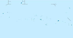
 Udot
Udot