Zámoly
- Zámoly
-
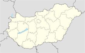
Zámoly est un village et une commune du comitat de Fejér en Hongrie.
Géographie
Cette section est vide, insuffisamment détaillée ou incomplète.
Votre aide est la bienvenue !
Histoire
Cette section est vide, insuffisamment détaillée ou incomplète.
Votre aide est la bienvenue !
Catégorie :
- Ville et village du comitat de Fejér
Wikimedia Foundation.
2010.
Contenu soumis à la licence CC-BY-SA. Source : Article Zámoly de Wikipédia en français (auteurs)
Regardez d'autres dictionnaires:
Zamoly — Zamoly, Dorf im Bezirk Moor des ungarischen Comitats Weißenburg; Weberei, Ziegelbrennerei, Weinbau; 2330 Ew … Pierer's Universal-Lexikon
Zámoly — Infobox Settlement subdivision type = Country subdivision name = HUN timezone=CET utc offset=+1 timezone DST=CEST utc offset DST=+2|official name=Zámoly subdivision type1=County subdivision name1=Fejér area total km2=48.5 population total=2216… … Wikipedia
Zamoly — Original name in latin Zmoly Name in other language Zamoly, Zmoly State code HU Continent/City Europe/Budapest longitude 47.31667 latitude 18.4081 altitude 146 Population 2194 Date 2012 05 06 … Cities with a population over 1000 database
Zamoly Roma — On 2 July 2000, 12 Roma families from the Hungarian village of Zamoly traveled to Strasbourg, France, where they demanded political asylum and protection from racial persecution after their houses had been destroyed. In 2001, 37 out of the… … Historical dictionary of the Gypsies
Fejér — 47°10′0″N 18°35′0″E / 47.16667, 18.58333 … Wikipédia en Français
Peter Urseolo of Hungary — Peter I the Venetian (Hungarian: I. (Velencei) Péter ) (c. 1010 1015, Venice, Italy ndash; 1046 or 30 August 1059), King of Hungary (1038 1041, 1044 1046). He continued his predecessor s policy and tried to strengthen the Christianity in his semi … Wikipedia
Fejér County — Infobox Hungarian county name =Fejér region =Central Transdanubia seat = Székesfehérvár area = 4359 population = 426,541 density = 98 cities = 108: For the historical county see Fejér (former county). : For the mathematician of the same name see… … Wikipedia
Dunaújváros — The bridge on the Danube … Wikipedia
Mór — For other uses, see Mór (disambiguation). Mór Lamberg Castle, Mór … Wikipedia
Martonvásár — Martonvásár, palace … Wikipedia


 Hongrie
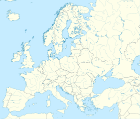

 Zámoly


