Bloomfield Hills
Contenu soumis à la licence CC-BY-SA. Source : Article Bloomfield Hills de Wikipédia en français (auteurs)
Regardez d'autres dictionnaires:
Bloomfield Hills — Bloomfield Hills … Deutsch Wikipedia
Bloomfield Hills — Bloomfield Hills, MI U.S. city in Michigan Population (2000): 3940 Housing Units (2000): 1628 Land area (2000): 4.947545 sq. miles (12.814082 sq. km) Water area (2000): 0.048433 sq. miles (0.125440 sq. km) Total area (2000): 4.995978 sq. miles… … StarDict's U.S. Gazetteer Places
Bloomfield Hills, MI — U.S. city in Michigan Population (2000): 3940 Housing Units (2000): 1628 Land area (2000): 4.947545 sq. miles (12.814082 sq. km) Water area (2000): 0.048433 sq. miles (0.125440 sq. km) Total area (2000): 4.995978 sq. miles (12.939522 sq. km) FIPS … StarDict's U.S. Gazetteer Places
Bloomfield Hills — Original name in latin Bloomfield Hills Name in other language State code US Continent/City America/Detroit longitude 42.58364 latitude 83.24549 altitude 256 Population 3869 Date 2011 05 14 … Cities with a population over 1000 database
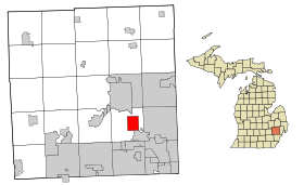
Bloomfield Hills (Michigan) — Bloomfield Hills Bloomfield Hills Pays États Unis État … Wikipédia en Français
Bloomfield Hills School District — (BHSD) is a school district in the U.S. state of Michigan. It was founded in the 1950s. BHSD has ranked among the best school systems in Michigan multiple times.chools*Wing Lake Developmental Center *Andover High School *Lahser High School… … Wikipedia
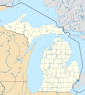
Bloomfield Hills, Michigan — Infobox Settlement official name = Bloomfield Hills, Michigan settlement type = City nickname = website = http://www.bloomfieldhillsmi.net mapsize = 250x200px map caption = Location in the state of Michigan mapsize1 = map caption1 = subdivision… … Wikipedia
Bloomfield Hills — ▪ Michigan, United States city, Oakland county, southeastern Michigan, U.S. It lies just southeast of Pontiac and northwest of Detroit. The site was settled in 1819 by Amasa Bagley and was known as Bagley s Corners and Bloomfield Center… … Universalium
Andover High School (Bloomfield Hills, Michigan) — Infobox High School name = Andover High School established = 1955 principal = Rob Durecka location = Bloomfield Hills, Michigan, USA mascot = Barons colors = Navy and White website=http://andover.bloomfield.org Andover High School is a public… … Wikipedia
Marian High School (Bloomfield Hills, Michigan) — Marian High School Address 7225 Lahser Road Bloomfield Hills, Michigan, (Oakland County), 48301 … Wikipedia
 États-Unis
 Michigan