Clayoquot Sound
- Clayoquot Sound
-

Clayoquot Sound dans l'Île de Vancouver
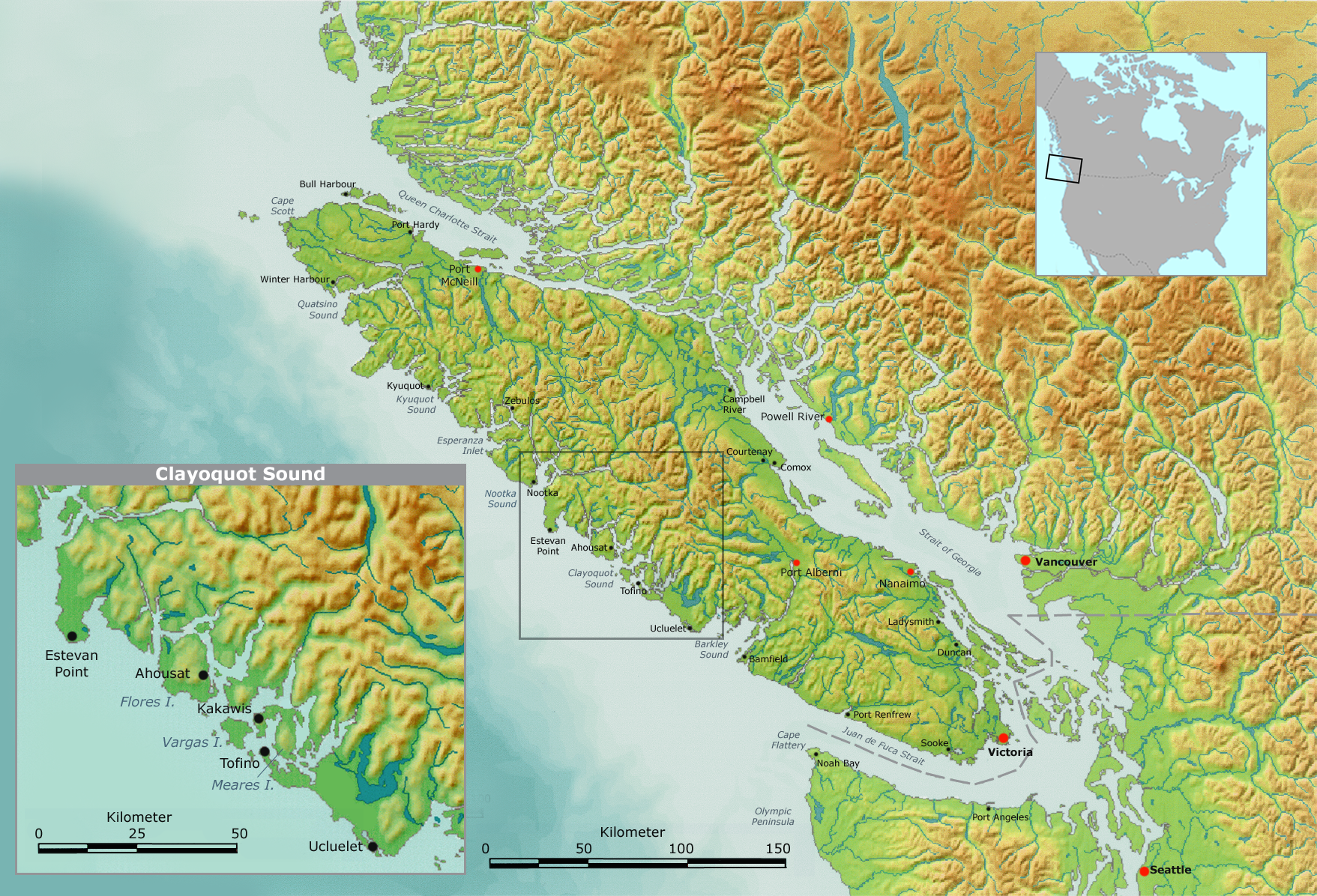
49°12′00″N 126°06′00″O / 49.2, -126.1 Le Clayoquot Sound (qui se prononce en général /ˈklækwɑt/) est le nom d'une zone côtière découpée située dans l'Ouest de l'île de Vancouver dans la province de Colombie-Britannique au Canada, qui couvre environ 2700 km2. Il s'étend de la péninsule d'Esowista sur le Barkley Sound au sud jusqu'à la péninsule de Hesquiaht sur le Nootka Sound au nord et comprend la baie elle-même ainsi que les terres voisines jusqu'à la chaîne de montagne.
La baie est bordée de forêts vierges appartenant à l'écosystème des forêts humides tempérées, de cours d'eau, de lacs et de plages. Elle comprend une partie des réserves du Pacific Rim National Park, le Strathcona Provincial Park et plusieurs autres zones protégées. Les seules localités un peu importantes sont Tofino et Ucluelet (chacune ayant à peu près 1500 habitants), toutes les deux se trouvent sur la langue de terre principale dans le Sud du territoire. Au cours des années 1990, la région a vu s'affronter les intérêts de la protection de la nature et ceux de l'exploitation forestière.
Le mot Clayoquot représente la transcription en anglais de « Tla-o-Qui-aht » qui désignait un peuple amérindien. Jusqu'en 1861 la baie s'appelait « Wickaninnish Sound ».
Liens externes
Sur les autres projets Wikimedia :
Wikimedia Foundation.
2010.
Contenu soumis à la licence CC-BY-SA. Source : Article Clayoquot Sound de Wikipédia en français (auteurs)
Regardez d'autres dictionnaires:
Clayoquot Sound — auf Vancouver Island Clayoquot Sound (/ˈklækwɑt/ ausgesprochen) ist der Name eines zerklüfteten Küstengebietes im Westen von Vancouver Island, Kanada von etwa 2700 km². Es reicht von der Esowista Halbinsel am Barkley Sound im Süden bis zur… … Deutsch Wikipedia
Clayoquot Sound — Map of Vancouver Island with inset of Clayoquot Sound region Clayoquot Sound ( / … Wikipedia
Clayoquot Sound Central Region Board — The Clayoquot Sound Central Region Board (CRB) was created as a result of the historic two year Interim Measures Agreement (IMA) in 1994. This agreement acknowledged that “the Ha’wiih (Hereditary Chiefs) of the First Nations have the… … Wikipedia
Clayoquot Sound — West coast of Vancouver Island. Index: D Natives of, attack Tonquin, 1811, and massacre crew, 37 … The makers of Canada
Clayoquot Arm Provincial Park — is a provincial park in British Columbia, Canada. See also Clayoquot Plateau Provincial Park Clayoquot Sound References Clayoquot Arm Park . BC Geographical Names. http://apps.gov.bc.ca/pub/bcgnws/names/41297.html … Wikipedia
Clayoquot Plateau Provincial Park — is a provincial park in British Columbia, Canada.[1] See also Clayoquot Sound Clayoquot Arm Provincial Park References ^ BCGNIS entry Clayoquot Plateau Park … Wikipedia
Clayoquot — /ˈklækwɒt/ is an anglicization of the Nuu chah nulth language name Tla o qui aht , one of the indigenous tribes of the region so named. It may refer to: Clayoquot Sound and the associated region, including: the Clayoquot River Clayoquot Arm… … Wikipedia
Sound (geografía) — Saltar a navegación, búsqueda Øresund del Norte … Wikipedia Español
Clayoquot — Wohngebiet Traditionelles Stammesgebiet der Tla o qui aht und Hauptreservate. Systematik Kulturareal … Deutsch Wikipedia
Sound (geography) — In geography a sound or seaway is a large sea or ocean inlet larger than a bay, deeper than a bight, wider than a fjord, or it may identify a narrow sea or ocean channel between two bodies of land (see also strait).There is little consistency in… … Wikipedia

 Portail de la Colombie-Britannique
 Portail du monde maritime