Darrous
- Darrous
-
35°46′N 51°27′E / 35.767, 51.45
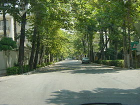
Darrous est un quartier au nord de Téhéran, Iran. Il est considerée comme l'un des secteurs les plus riches de la ville. Darrous est bordé par les quartiers de Pasdaran, Gholhak, Doulat, et Ekhtiyarieh.
Haj Mokhber ol Saltaneh Hedayat, un aristocrate renommé de la dernière période qajar, était le principal propriétaire terrien ; terres qui consistaient alors en de grands jardins et fermes du secteur jusqu'en 1950. Hedayat servit plusieurs fois comme premier ministre durant le règne de Reza Shah Pahlavi. Son héritage survit dans le quartier sous la forme d'une mosquée, d'une clinique médicale, et d'une école, toutes nommées Hedayat et situées sur la rue Hedayat.
Liens internes
Wikimedia Foundation.
2010.
Contenu soumis à la licence CC-BY-SA. Source : Article Darrous de Wikipédia en français (auteurs)
Regardez d'autres dictionnaires:
Darrous — is a neighborhood in Shemiran, northern Tehran, Iran. It is considered one of the more affluent areas in the city, many modern and fashionable families reside there. Darrous is bounded by Pasdaran, Gholhak, Doulat, and Ekhtiyarieh. Haj Mehdi… … Wikipedia
Darrous — Hedayat Straße Darrous ist ein Stadtteil im Norden von Teheran. Er grenzt an die Viertel Pasdaran, Gholhak, Doulat und Ekhtiyarieh. Vor 1950 gehörte das meiste Land in diesem Stadtteil Gärten sowie Ländereien dem Aristokraten und… … Deutsch Wikipedia
Tehran — This article is about the Iranian capital city. For other uses, see Tehran (disambiguation). Tehran تهران … Wikipedia
Davoodiyeh — A statue in Mirdamad Square in Davoodiyeh Davoodiyeh is a large district of northern Tehran, Iran. Davoodiyeh is also called Mirdamad because the area is centered around Mirdamad Blvd. Davoodiyeh is a high density, upscale district of shops,… … Wikipedia
List of the localities around Tehran — Map = A = *Aba Barik *Ab Ali *Pist e Eski ye Abali *Ab Anjirak *Abar Dezh *Abasabad *Ab Barik *Ferheng *Abbasabad *Abbasabad e Alaqeh Band *Abbasabad e Bozorg *Abbasabad e Dara i *Abbasabad e Ferdows *Abbasabad e Jajrud *Abbasabad e Jalrud… … Wikipedia
Darband, Tehran — The foot of Darband s popular hiking trail in Tehran … Wikipedia
Niavaran — The Niavaran branch of the National Library of Iran offers a pleasant environment for its users … Wikipedia
Pasdaran (district) — Pasdaran is a neighborhood of northern Tehran centered around eastern side of Pasdaran Ave. This avenue connects Niavaran avenue (from the north) to Shariati avenue (in the south). It is about 8 9 km long and is a major commercial thoroughfare… … Wikipedia
Gheytarieh — (also spelled Qeytarieh) is a district, in northeastern Tehran s city limits, within the larger Shemiran district. Gheytarieh has about 150,000 residents.Gheytarieh is famous for a large park with the same name. Gheytarieh Park was once the home… … Wikipedia
Mahmoodieh — or Mahmoodiyeh is an affluent residential area in Tehran, located south of Zaferaniyeh, bordering Valiasr Avenue on the east side, Velenjak on the west, and Chamran expressway to the south. The area is in close proximity to Tajrish. Mahmoodieh… … Wikipedia