Delungra
Contenu soumis à la licence CC-BY-SA. Source : Article Delungra de Wikipédia en français (auteurs)
Regardez d'autres dictionnaires:
Delungra, New South Wales — Delungra New South Wales Delungra … Wikipedia
Contenu:Australie — Projet:Australie/Liste des articles Liste mise à jour régulièrement par MyBot (d · c · b) à partir des articles liés au bandeau {{Portail Australie}} Modifications récentes des articles ayant le bandeau de ce portail… … Wikipédia en Français
Murchison County — Map of all coordinates from Google Map of all coordinates from Bing Export all coordinates as KML … Wikipedia
New England (New South Wales) — New England New South Wales Mount Duval in New England Population … Wikipedia
Oxley Wild Rivers National Park — Oxley Wild Rivers IUCN Category Ib (Wilderness Area) Apsley Falls, Walcha, NSW showing one of several lookouts Nearest town/city Walcha … Wikipedia
New England (Australia) — Infobox Australian Place | type = region name = New England state = nsw caption = Mt Duval in the New England lga = pop = 175,883 cite web url = http://www.business.nsw.gov.au/region/profiles/newengland northwest.htm title = Department of State… … Wikipedia
Manilla, New South Wales — Manilla New South Wales Clock tower in the main street of Manilla … Wikipedia
Myall Creek massacre — Location Myall Creek, 16 km north east of Bingara and 40km west of Inverell, New South Wales Coordinates … Wikipedia
Moonbi, New South Wales — Moonbi New South Wales Moonbi valley from the Moonbi Range … Wikipedia
Graman, New South Wales — Graman is a small village nestled on the banks of Graman Creek, 40 km northwest of Inverell and 25 km from Ashford in Inverell Shire, New South Wales, Australia. The village is situated on the Inverell to Yetman road at elevation of about 606… … Wikipedia
 En arrivant à Delungra.
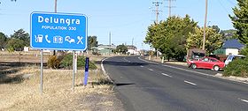 La grand rue de Delungra
 Australie
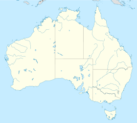
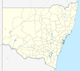
 Delungra