- District De Gänserndorf
-
District de Gänserndorf
Gänserndorf 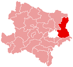
Informations Pays  Autriche
Land  Basse-Autriche
Centre administratif Gänserndorf Superficie 1 271,31 km² Population 88 475 hab (15 mai 2001) Densité 70 hab/km² Immatriculation GF Le district de Gänserndorf est une subdivision territoriale du Land de Basse-Autriche en Autriche.
Sommaire
Géographie
Relief
Lieux administratifs voisins
Économie et infrastructures
Communes
Le district de Gänserndorf est subdivisé en 44 communes :
- Aderklaa
- Andlersdorf
- Angern an der March
- Auersthal
- Bad Pirawarth
- Deutsch-Wagram
- Drösing
- Dürnkrut
- Ebenthal
- Eckartsau
- Engelhartstetten
- Gänserndorf
- Glinzendorf
- Gross-Enzersdorf
- Gross-Schweinbarth
- Grosshofen
- Haringsee
- Hauskirchen
- Hohenau an der March
- Hohenruppersdorf
- Jedenspeigen
- Lassee
- Leopoldsdorf im Marchfelde
- Mannsdorf an der Donau
- Marchegg
- Markgrafneusiedl
- Matzen-Raggendorf
- Neusiedl an der Zaya
- Obersiebenbrunn
- Orth an der Donau
- Palterndorf-Dobermannsdorf
- Parbasdorf
- Prottes
- Raasdorf
- Ringelsdorf-Niederabsdorf
- Schönkirchen-Reyersdorf
- Spannberg
- Strasshof an der Nordbahn
- Sulz im Weinviertel
- Untersiebenbrunn
- Velm-Götzendorf
- Weiden an der March
- Weikendorf
- Zistersdorf
 Portail de l’Autriche
Catégories : District d'Autriche | Basse-Autriche

Wikimedia Foundation. 2010.