Airdrie (North Lanarkshire)
- Airdrie (North Lanarkshire)
-
55° 52′ N 3° 59′ W / 55.86, -3.98
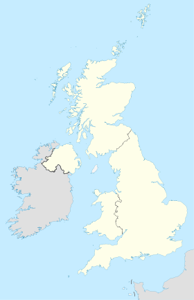
Airdrie est une ville écossaise située dans le North Lanarkshire. Elle se trouve à 19 km à l’est de Glasgow à une altitude de 130 m. La ville forme avec sa voisine Coatbridge, la région des Monklands. En 2006 sa population s’élevait à 36 326 habitants[1]. Les villages de Chapelhall, Calderbank, Glenmavis, Greengairs, Plains et Caldercruix sont des satellites d’Airdrie.
Toponymie
L’origine du nom d’Airdrie n’est pas formellement connue. Toutefois l’interprétation la plus répandue provient du gaélique An Àrd Ruigh qui rappelle un lieu en altitude ou un pâturage sur un lieu élevé. Une autre possibilité renvoie à An Àrd Àirighe qui signifie une ville de passage.
Histoire
Cette section est vide, insuffisamment détaillée ou incomplète.
Votre aide est la bienvenue !
Administration
Cette section est vide, insuffisamment détaillée ou incomplète.
Votre aide est la bienvenue !
Démographie
Cette section est vide, insuffisamment détaillée ou incomplète.
Votre aide est la bienvenue !
Économie
Cette section est vide, insuffisamment détaillée ou incomplète.
Votre aide est la bienvenue !
Culture
Cette section est vide, insuffisamment détaillée ou incomplète.
Votre aide est la bienvenue !
Sport
Cette section est vide, insuffisamment détaillée ou incomplète.
Votre aide est la bienvenue !
Notes et références
Wikimedia Foundation.
2010.
Contenu soumis à la licence CC-BY-SA. Source : Article Airdrie (North Lanarkshire) de Wikipédia en français (auteurs)
Regardez d'autres dictionnaires:
Airdrie (North Lanarkshire) — Airdrie Koordinaten 55° 52′ N … Deutsch Wikipedia
Airdrie, North Lanarkshire — infobox UK place country = Scotland official name= Airdrie gaelic name= An Àrd Ruigh or An Àrd Àirighe scots name= Airdrie population= 36,326 os grid reference= NS761654 map type= Scotland latitude=55.86 longitude= 3.98 unitary scotland= North… … Wikipedia
North Lanarkshire (UK Parliament constituency) — North Lanarkshire Former County constituency for the House of Commons 1885 (1885)–1983 (1983) … Wikipedia
North Lanarkshire — Siorrachd Lannraig a Tuath Verwaltungssitz Motherwell Fläche … Deutsch Wikipedia
North Lanarkshire Council election, 2007 — Elections to North Lanarkshire Council were held on the May 3, 2007 the same day as the other Scottish local government elections and the Scottish Parliament general election. The election was the first one using 20 new wards created as a results … Wikipedia
North Lanarkshire — Coordinates: 55°49′44″N 3°55′19″W / 55.829°N 3.922°W / 55.829; 3.922 … Wikipedia
North Lanarkshire — NorthLanarkshire / Siorrachd Lannraig un Tuath Consejo unitario de Escocia Situación de North Lanarkshire en Escocia … Wikipedia Español
North Lanarkshire — 55° 49′ 44″ N 3° 55′ 19″ W / 55.829, 3.922 … Wikipédia en Français
North Lanarkshire Council election, 1999 — Elections to North Lanarkshire Council were held on the May 6, 1999 the same day as the other Scottish local government elections and the Scottish Parliament general election. Election results North Lanarkshire Local Election Result 1999 Party… … Wikipedia
North Lanarkshire Council election, 2003 — Elections to North Lanarkshire Council were held on the May 1, 2003 the same day as the other Scottish local government elections and the Scottish Parliament general election. Election results North Lanarkshire Local Election Result 2003 Party… … Wikipedia
 Royaume-Uni
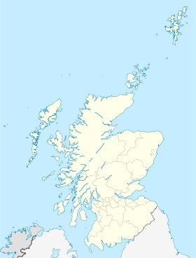
 Airdrie