Akdağmadeni
- Akdağmadeni
-
Akdaĝmadeni est une petite sous-préfecture de 24 000 habitants située à 60 km à l'est de la ville de Yozgat en Turquie. Ancienne ville minière, elle possède aussi de vastes étendues de forêts de conifères. Quatre-vingts villages dépendent de son administration. Elle est également la terre natale de Nida Tüfekçi.
Voir aussi
Catégories :
- Ville de Turquie
- District de Turquie
- Localité de la région de l'Anatolie centrale
Wikimedia Foundation.
2010.
Contenu soumis à la licence CC-BY-SA. Source : Article Akdağmadeni de Wikipédia en français (auteurs)
Regardez d'autres dictionnaires:
Akdağmadeni — Infobox Settlement settlement type = District subdivision type = Country subdivision name = TUR timezone= EET utc offset=+2 map caption =Location of PAGENAME within Turkey. timezone DST=EEST utc offset DST=+3 official name = Akdağmadeni image… … Wikipedia
Akdagmadeni — Original name in latin Akdamadeni Name in other language Adagmadeni, Adamaden Akdagmadeni, Akdamadeni State code TR Continent/City Europe/Istanbul longitude 39.66028 latitude 35.88361 altitude 1313 Population 23048 Date 2012 01 18 … Cities with a population over 1000 database
Akdağmadeni — is., öz. Yozgat iline bağlı ilçelerden biri … Çağatay Osmanlı Sözlük
Başçatak — Hilfe zu Wappen … Deutsch Wikipedia
Provincia de Yozgat — Saltar a navegación, búsqueda Localización de la provincia de Yozgat. La provincia de Yozgat es una de las 81 provincias de Turquía. Superficie: ? km² Población (2000): ? hab Densidad de población: ? Hab/km² Capital: Yozgat … Wikipedia Español
List of cities in Turkey — The National Flag of Turkey This list is incomplete; you can help by expanding it. This is a list of cities in Turkey by population. Included are cities that are provincial capitals or have a population of at least 7,000 … Wikipedia
Yozgat Province — Infobox Province TR region = Central Anatolia name = Yozgat licence = 66 total population = 727,394 area code= 354 area=14,123|Yozgat is a province in central Turkey. Its adjacent provinces are Çorum to the northwest, Kırıkkale to the west,… … Wikipedia
Kadışehri — Infobox Settlement settlement type = District subdivision type = Country subdivision name = TUR timezone= EET utc offset=+2 map caption =Location of PAGENAME within Turkey. timezone DST=EEST utc offset DST=+3 official name = Kadışehri image… … Wikipedia
Halay — (Assyrian: Khigga ܚܓܐ, Greek: Χαλάϊ , Kurdish: Dilan / Gowend , Turkish: Halay , Zazaish: Gowend ) is a popular dance in the Middle East.Halay is traditionally played on the zurna, supported by a davul, but in the recent years, electronic… … Wikipedia
Districts of Turkey — Republic of Turkey This article is part of the series: Politics and government of the Republic of Turkey … Wikipedia

 Turquie
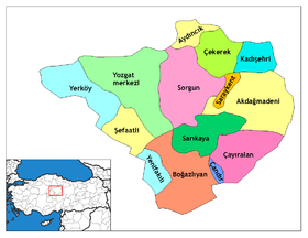
 Akdaĝmadeni

