Gladesville Bridge
- Gladesville Bridge
-
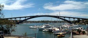
Gladesville Bridge est un pont en arc situé à Gladesville, un quartier de Sydney en Australie, sur la Parramatta River. Il est situé à quelques kilomètres en amont du célèbre pont de Sydney. Au moment de sa construction, entre 1959 et 1964, il était le plus long pont au monde à une seule arche et en béton construit au monde. C'est le plus grand des trois ponts de la North Western Expressway.
Références
- Powell, Carol. A River Revived: the Parramatta. Kensington, N.S.W.: New South Wales University Press, 1987. ISBN 0-86840-138-2.
- Russell, Eric. Drummoyne: a western suburbs' history from 1794. Drummoyne, N.S.W.: Council of the Municipality of Drummoyne, Second Edition, 1982. ISBN 0-9599312-1-X.
- Engineering Heritage Committee, Parramatta River Bridges by River Cat, The Institution of Engineers Australia Sydney Division
Wikimedia Foundation.
2010.
Contenu soumis à la licence CC-BY-SA. Source : Article Gladesville Bridge de Wikipédia en français (auteurs)
Regardez d'autres dictionnaires:
Gladesville Bridge — is an arch bridge in Gladesville that spans the Parramatta River, west of central Sydney, Australia. It is a few kilometres upstream of the more famous Sydney Harbour Bridge and is part of Victoria Road. At the time of its completion in 1964,… … Wikipedia
Gladesville, New South Wales — Gladesville Sydney, New South Wales Bedlam Point, Gladesville Population … Wikipedia
Gladesville — Bedlam Point in Gladesville Staat … Deutsch Wikipedia
Gladesville-Brücke — 33.841944444444151.14777777778 Koordinaten: 33° 50′ 31″ S, 151° 8′ 52″ O f1 … Deutsch Wikipedia
Fig Tree Bridge — is a girder bridge that spans the Lane Cove River, west of the CBD in Sydney, Australia. It is immediately to the north of Tarban Creek Bridge and the more well known Gladesville Bridge. The bridge carries Burns Bay Road and a footpath and… … Wikipedia
Tarban Creek Bridge — is an arch bridge that spans Tarban Creek, west of central Sydney, Australia. It is located between Gladesville Bridge and Fig Tree Bridge, being immediately to the north of Gladesville Bridge. The bridge carries Burns Bay Road and a footpath and … Wikipedia
Burnt Bridge Creek Deviation — The Burnt Bridge Creek Deviation is a 1.5 km stretch of freeway grade road in the Northern Beaches area of Sydney, New South Wales, Australia. It forms part of Metroad 10 and is the only freeway grade section of that route.It begins just past the … Wikipedia
Silverwater Bridge — in the north.Other crossings over the Parramatta River include the Gladesville Bridge and Ryde Bridge.HistoryThe origin of the suburb s name, and subsequently the bridge s name, is unknown. It may have been a reference to the nearby Parramatta… … Wikipedia
Parramatta River — von der Gladesville Bridge ausVorlage:Infobox Fluss/KARTE fehlt … Deutsch Wikipedia
Parramatta River — Infobox River river name = Parramatta River caption = Parramatta River from Gladesville Bridge origin = New South Wales mouth = Port Jackson basin countries = Australia watershed = 130 km²The Parramatta River is a waterway in Sydney, New South… … Wikipedia