Godmanchester

Godmanchester
Godmanchester

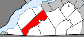
Localisation du canton dans la MRC de Le Haut-Saint-Laurent

Administration
Pays Drapeau du Canada Canada
Province Drapeau : Québec Québec
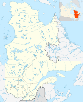
Région Montérégie
Comté ou équivalent Le Haut-Saint-Laurent
Statut municipal Canton
Constitution 1er juillet 1855
Maire
Mandat en cours
Pierre Poirier
2009 - 2013
Démographie
Population 1 532 hab. (2006)
Densité 11 hab./km2
Gentilé Godmancastrien(ne)
Géographie
Coordonnées
géographiques
45° 05′ 00″ N 74° 15′ 00″ W / 45.083338, -74.25000545° 05′ 00″ N 74° 15′ 00″ W / 45.083338, -74.250005
Superficie 138,77 km2
Code géographique 69060

Géolocalisation sur la carte : Québec

(Voir situation sur carte : Québec)
Godmanchester

Godmanchester est une municipalité de canton dans la municipalité régionale de comté du Haut-Saint-Laurent au Québec, située dans la région administrative de la Montérégie.

Historique

C'est en 1845 qu'est fondée la municipalité de canton de Godmanchester, soit 34 ans après l'établissement du canton homonyme. Cependant, la municipalité est abolie en 1847 et rétablie en 1855. Durant ces sept années, le territoire fut rattaché à la municipalité du comté de Beauharnois. Lors du rétablissement de la municipalité, le territoire se retrouve amputé d'une petite portion de territoire comprenant Huntingdon des suites de la fondation de ce village en 1848. La municipalité se retrouve aussi amputée d'une autre partie du territoire avec l'établissement de Saint-Anicet.

L'origine du nom Godmanchester est reliée à un village du comté de Huntingdon en Angleterre. C'est l'arpenteur de l'endroit William Chewett qui décida de ce nom. Cependant, le nom du village anglais serait une dérivation de Gormon Castria. Le terme Castria, qui signifie camp en latin, fut utilisé durant l'époque romaine et se modifia graduellement sous la forme de Chester.

Le gentilé des citoyens de Godmanchester est Godmancastrien. Ce choix fut adopté en 1986, probablement dans le but de renouer avec les origines latines du nom de la municipalité et dans le but de doter d'une consonance française pour être en harmonie avec la langue de Molière, langue officielle du Québec.


Municipalités limitrophes

Sources


Wikimedia Foundation. 2010.

Contenu soumis à la licence CC-BY-SA. Source : Article Godmanchester de Wikipédia en français (auteurs)

Игры ⚽ Нужно решить контрольную?

Regardez d'autres dictionnaires:

  • Godmanchester — (spr. goddmänntschester), Stadt, s. Huntingdon …   Meyers Großes Konversations-Lexikon

  • Godmanchester — Coordinates: 52°19′03″N 0°10′21″W / 52.317616°N 0.172526°W / 52.317616; 0.172526 …   Wikipedia

  • Godmanchester — 52.318055555556 0.16999999999999 Koordinaten: 52° 19′ N, 0° 10′ W …   Deutsch Wikipedia

  • Godmanchester — Original name in latin Godmanchester Name in other language Durolipons, Godmanchester State code GB Continent/City Europe/London longitude 52.31939 latitude 0.17509 altitude 12 Population 5965 Date 2010 08 03 …   Cities with a population over 1000 database

  • Godmanchester Chinese Bridge — is a landmark of the town of Godmanchester, Huntingdonshire (now administered as part of Cambridgeshire, England). It is a pedestrian bridge that spans the River Great Ouse and is, as the name suggests, built in an ostensibly Chinese style. The… …   Wikipedia

  • Godmanchester Rovers F.C. — Football club infobox clubname = Godmanchester Rovers fullname = Godmanchester Rovers Football Club nickname = Rovers founded = 1911 ground = Beasrcroft Lane Godmanchester capacity = chairman = Keith Gabb manager = Karly Hurst league = Eastern… …   Wikipedia

  • Godmanchester, Quebec — Infobox Settlement name = Godmanchester, Quebec other name = native name = nickname = settlement type = Township (Canton) motto = imagesize = image caption = flag size = image seal size = image shield = shield size = city logo = citylogo size =… …   Wikipedia

  • Huntingdon and Godmanchester — Coordinates: 52°19′08″N 0°10′30″W / 52.319°N 0.175°W / 52.319; 0.175 …   Wikipedia

  • Civil parishes in Cambridgeshire — A map of Cambridgeshire, showing the Districts, clockwise from the top left: Peterborough; Fenland; East Cambridgeshire; South Cambridgeshire; Cambridge; and Huntingdonshire. A civil parish is a subnational entity, forming the low …   Wikipedia

  • Huntingdon (Quebec) — Huntingdon (Québec) Pour les articles homonymes, voir Huntingdon. Huntingdon Ajouter une image Administration …   Wikipédia en Français

Share the article and excerpts

Direct link
Do a right-click on the link above
and select “Copy Link”