Graettinger (Iowa)
- Graettinger (Iowa)
-
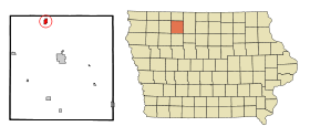
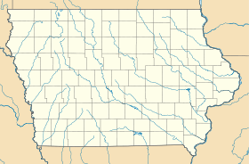
Graettinger est une ville du comté de Palo Alto, situé dans l'Iowa, États-Unis. La population était de 900 habitants lors du recensement de 2000.
Histoire
La ville a été fondée par des colons allemands qui sont arrivés pour la première fois à Graettinger.
Graettinger est le lieu de la plus ancienne fête du travail (Labor Day) dans l'État de l'Iowa. Chaque année, la ville célèbre ce jour avec un défilé de danse de rue, un spectacle de variétés, le couronnement d'une reine, un concours de dessin et d'autres événements.
Wikimedia Foundation.
2010.
Contenu soumis à la licence CC-BY-SA. Source : Article Graettinger (Iowa) de Wikipédia en français (auteurs)
Regardez d'autres dictionnaires:
Graettinger (Iowa) — Graettinger Ciudad de los Estados Unidos … Wikipedia Español
Graettinger, Iowa — Infobox Settlement official name = Graettinger, Iowa settlement type = City nickname = motto = imagesize = image caption = image imagesize = image caption = image mapsize = 250x200px map caption = Location of Graettinger, Iowa mapsize1 = map… … Wikipedia
Iowa Highway 4 — Infobox road state=IA type=IA route=4 alternate name= length mi=146 length round=0 length ref=Iowahighwaysref|lowrg=1|hirng=9|num=4|access date=November 7, 2007] established= direction a=South starting terminus=Jct|state=IA|IA|44|city1=Panora… … Wikipedia
Graettinger — Graettinger, IA U.S. city in Iowa Population (2000): 900 Housing Units (2000): 430 Land area (2000): 0.766097 sq. miles (1.984182 sq. km) Water area (2000): 0.000000 sq. miles (0.000000 sq. km) Total area (2000): 0.766097 sq. miles (1.984182 sq.… … StarDict's U.S. Gazetteer Places
Graettinger, IA — U.S. city in Iowa Population (2000): 900 Housing Units (2000): 430 Land area (2000): 0.766097 sq. miles (1.984182 sq. km) Water area (2000): 0.000000 sq. miles (0.000000 sq. km) Total area (2000): 0.766097 sq. miles (1.984182 sq. km) FIPS code:… … StarDict's U.S. Gazetteer Places
List of high schools in Iowa — This is a list of high schools in the state of Iowa. You can also see a list of school districts in Iowa.Adair County*Nodaway Valley Community School District **Nodaway Valley High School, GreenfieldAdams County*Corning High School,… … Wikipedia
Ayrshire (Iowa) — Ayrshire Administration Pays États Unis … Wikipédia en Français
Mallard (Iowa) — Mallard Administration Pays États Unis … Wikipédia en Français
West Bend (Iowa) — 42° 57′ 33″ N 94° 26′ 45″ W / 42.959167, 94.445833 … Wikipédia en Français
Curlew (Iowa) — 42° 58′ 49″ N 94° 44′ 15″ W / 42.980278, 94.737500 … Wikipédia en Français
 États-Unis
 Iowa
Iowa