Guyandotte
- Guyandotte
-
38°25′54″N 82°23′30″O / 38.43167, -82.39167
| Guyandotte |
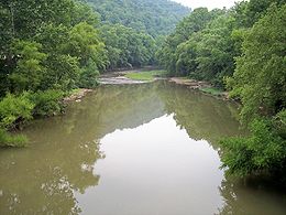
La Guyandotte vue vers l'aval depuis la County Road 12 dans West Logan. |
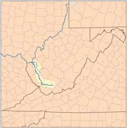
Le bassin de la rivière Guyandotte s'étend au sud-ouest de la Virginie-Occidentale. |
| Caractéristiques |
| Longueur |
267 km |
| Bassin |
? |
| Bassin collecteur |
Mississippi |
| Débit moyen |
? |
| Cours |
| Se jette dans |
Ohio |
| Géographie |
| Pays traversés |
 Virginie-Occidentale, Virginie-Occidentale,
 États-Unis États-Unis |
| Principales villes |
Barboursville, Chapmanville, Gilbert, Harts, Huntington, Logan, Man, Mullens, Pineville, West Hamlin, West Logan |
La Guyandotte ((en) Guyandotte River) est une rivière des États-Unis longue de 267 kilomètres, affluent de la rivière Ohio, donc un sous-affluent du Mississippi.
Parcours
La rivière débute au sud-ouest du comté de Raleigh au confluent entre deux ruisseaux Winding Gulf et Stonecoal Creek et se dirige d'abord vers l'ouest à travers les comtés de Wyoming et Mingo. Puis la rivière change de direction et s'écoule vers le nord-ouest à travers les comtés de Logan, Lincoln et Cabell pour se jeter dans la rivière Ohio à Huntington à 8 kilomètres à l'est du centre-ville.
Un barrage a été construit sur la rivière dans le comté de Mingo et forme le lac R.D. Bailey[1].
Principaux affluents
La rivière Mud se jette dans la rivière Guyandotte à Barboursville dans le comté de Cabell.
Principales villes situées sur les rives de la rivière
Liens externes
Notes et références
Catégories :
- Cours d'eau de Virginie-Occidentale
- Système hydrologique du Mississippi
Wikimedia Foundation.
2010.
Contenu soumis à la licence CC-BY-SA. Source : Article Guyandotte de Wikipédia en français (auteurs)
Regardez d'autres dictionnaires:
Guyandotte — Guyandotte, 1) (G. River), Fluß im Westen des Staates Virginia (Nordamerika), entspringt in der Grafschaft Logan u. fällt in der Grafschaft Cabell in den Ohio River; 2) Postort in der Grafschaft Cabell des Staates Virginia an der Mündung des G.… … Pierer's Universal-Lexikon
Guyandotte River — Guyandotte Guyandotte la Guyandotte vue vers l aval depuis la County Road 12 dans West Logan … Wikipédia en Français
Guyandotte River — The Guyandotte River is a tributary of the Ohio River, approximately 166 mi (267 km) long, in southwestern West Virginia in the United States. It drains an area of the unglaciated Allegheny Plateau south of the Ohio between the watersheds of the… … Wikipedia
Upper Guyandotte Watershed Association — The Upper Guyandotte Watershed Association (UGWA) is a 501(c)(3) non profit corporation located in Mullens, West Virginia. UGWA was officially founded in December, 2002 in response to the water quality problems that have negatively affected our… … Wikipedia
Huntington, West Virginia — City of Huntington, West Virginia City Huntington s Central Business District as seen from the Robert C. Byrd Bridge at 6th Street … Wikipedia
Mud River (West Virginia) — The Mud River in Milton in 2007 A map of the Guyandotte … Wikipedia
Гайандотт — Guyandotte River … Википедия
Mullens, West Virginia — City Howard Avenue in downtown Mullens in 2007 … Wikipedia
R. D. Bailey Lake — Infobox lake lake name = R. D. Bailey Lake image lake = R.D. Bailey Lake Dam.jpg caption lake = Dam image bathymetry = caption bathymetry = location = West Virginia coords = coord|37.6001097|N|81.8223383|W|region:US… … Wikipedia
Big Sandy, East Lynn and Guyan Railroad — In the 1890s, plans were made for a railroad to connect the Big Sandy River and Guyandotte River. The planned railroad would start at the mouth of Whites Creek on the Big Sandy River in Wayne County, West Virginia and would proceed to the East… … Wikipedia