Hellouw

Hellouw

51° 49′ 39″ N 5° 10′ 37″ E / 51.8275, 5.17694

Hellouw
Administration
Pays Drapeau : Pays-Bas Pays-Bas
Province Gueldre
Commune Neerijnen
Géographie
Population 960 hab. (2008)
Autres informations
Code postal 4174
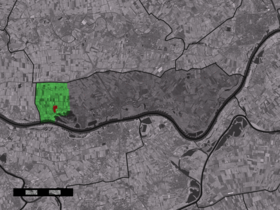
Localisation de Hellouw dans la commune de Neerijnen

Hellouw est un village néerlandais de la commune de Neerijnen, situé dans la province du Gueldre.

Géographie

Hellouw est situé sur la rive droite du Waal, dans la partie orientale de Vijfheerenlanden, entre Herwijnen et Haaften.

Histoire

En 1840, Hellouw appartenait à la commune de Haaften et comptait 90 maisons et 560 habitants[1]. Depuis le 1er janvier 1978 Hellouw a fusionné dans la commune de Neerijnen.

Référence

  1. Alphabetisch register van alle bewoonde oorden des Rijks, Departement van Oorlog, Éd. Erven Doorman, 's-Gravenhage, 1850

Wikimedia Foundation. 2010.

Contenu soumis à la licence CC-BY-SA. Source : Article Hellouw de Wikipédia en français (auteurs)

Игры ⚽ Нужна курсовая?

Regardez d'autres dictionnaires:

  • Hellouw — Dutch town locator maps mun town caption = The town centre (red) and the statistical district (light green) of Hellouw in the municipality of Neerijnen.Hellouw (coord|51|50|N|5|11|E|type:city(482)) is a town in the Dutch province of Gelderland.… …   Wikipedia

  • Haaften — 51° 49′ 01″ N 5° 12′ 42″ E / 51.8169, 5.21167 …   Wikipédia en Français

  • Neerijnen —   Municipality   Flag …   Wikipedia

  • Kinderdijk — Coordinates: 51°53′N 4°38′E / 51.883°N 4.633°E / 51.883; 4.633 …   Wikipedia

  • List of places in the Netherlands — This is an alphabetical list of places (cities, towns, villages) in the Netherlands. Lists per province can be found at:* List of towns in Groningen * List of towns in Friesland * List of towns in Drente * List of towns in Overijssel * List of… …   Wikipedia

  • De Adriaan, Haarlem — Windmill De Adriaan De Adriaan is a windmill in the Netherlands that burnt down in 1932 and was rebuilt in 2002. The original windmill dates from 1779 and the mill has been a distinctive part of the skyline of Haarlem for centuries. Contents …   Wikipedia

  • Haaften — Karte von 1421. Haaften liegt gegenüber „Boemel“ Zaltbommel im „T“ des Wortes Hertogdom Haaften ist ein Deichdorf und Hauptplatz der ehemaligen Gemeinde Haaften in der niederländischen Provinz Gelderland, die seit der Gebietsreform 1978 zur… …   Deutsch Wikipedia

  • Neerijnen — Gemeinde Neerijnen Flagge Wappen Provinz …   Deutsch Wikipedia

  • Est (Gueldre) — 51° 51′ 09″ N 5° 18′ 49″ E / 51.8525, 5.31361 …   Wikipédia en Français

  • Heesselt — 51° 48′ 47″ N 5° 20′ 48″ E / 51.8131, 5.34667 …   Wikipédia en Français

Share the article and excerpts

Direct link
Do a right-click on the link above
and select “Copy Link”