High Barnet
- High Barnet
-
High Barnet (métro de Londres)
 High Barnet High Barnet |
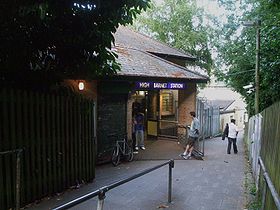
L'entrée de la station |
| Localisation |
| District de Londres |
Barnet |
| Gestion et exploitation |
| Ligne |
 Northern Northern |
| Caractéristiques |
| Quais |
3 |
| Transit annuel |
2,278 millions (2006)
2,613 millions (2007) |
| Zone |
5 |
| Historique |
| Mise en service |
1872 |
High Barnet est une station du métro de Londres, située dans le nord de Londres.
Elle est le terminus de branche High Barnet de la Northern Line et se situe en zone Travelcard 5. C'est la station la plus au nord de la Northern Line et se situe à 16,4 km (10,2 miles) au nord nord-ouest de Charing Cross. La station suivante est Totteridge and Whetstone.
Historique de la station
La station est construite en 1872 par la Great Northern Railway. C'était à l'époque la dernière station de la ligne allant de Finsbury Park à Edgawre via Highgate (ligne EH&LR).
Voir aussi
Article connexe
 Portail du chemin de fer
 Portail de Londres
 Portail des transports en commun
Catégories : Northern line | Barnet (district londonien) | Station du métro de Londres
Wikimedia Foundation.
2010.
Contenu soumis à la licence CC-BY-SA. Source : Article High Barnet de Wikipédia en français (auteurs)
Regardez d'autres dictionnaires:
High Barnet — Original name in latin High Barnet Name in other language State code GB Continent/City Europe/London longitude 51.65621 latitude 0.20768 altitude 133 Population 7062 Date 2011 03 03 … Cities with a population over 1000 database
High Barnet tube station — is a London Underground station in High Barnet in North London.The station is the terminus of the High Barnet branch of the Northern Line and is in Travelcard Zone 5. It is the northernmost station on the Northern Line and is situated 10.2 miles… … Wikipedia
High Barnet (metro de Londres) — High Barnet (métro de Londres) High Barnet L entrée de la station Localisation District … Wikipédia en Français
High barnet (métro de londres) — High Barnet L entrée de la station Localisation District … Wikipédia en Français
High Barnet (London Underground) — Bahnsteig Stati … Deutsch Wikipedia
High Barnet (métro de Londres) — High Barnet L entrée de la station Localisation District de Lo … Wikipédia en Français
Barnet Museum — was opened in March 1938 to house the collection of the Barnet and District Local History Society. Its building is an early Georgian house in the heart of High Barnet. The Museum contains archives, objects, prints, photographs, paintings and maps … Wikipedia
Barnet — (Chipping oder High Barnet), Stadt in Hertfordshire (England), nordwestlich von London, hat eine Lateinschule und (1901) 7876 Einw. Nördlich davon (auf Hadley Green) ein Obelisk zur Erinnerung an den Sieg Eduards IV. (14. April 1471) über den… … Meyers Großes Konversations-Lexikon
Barnet — For other uses, see Barnet (disambiguation). Coordinates: 51°38′40″N 0°11′59″W / 51.6444°N 0.1997°W / 51.6444; 0.1997 … Wikipedia
Barnet F.C. — Football club infobox clubname = Barnet fullname = Barnet Football Club nickname = The Bees founded = 1888 ground = Underhill Stadium Barnet, London England capacity = 5,568 chairman = flagicon|England Anthony Kleanthous manager =… … Wikipedia
