Hulshout
- Hulshout
-
 Hulshout Hulshout |
|
|
|
|
|
| Géographie |
| Pays |
 Belgique Belgique |
| Région |
 Région flamande Région flamande |
| Communauté |
Communauté flamande |
| Province |
 Province d'Anvers Province d'Anvers |
| Arrondissement |
Turnhout |
| Coordonnées |
51° 04′ 00″ N 4° 47′ 00″ E / 51.066666666667, 4.783333333333351° 04′ 00″ Nord
4° 47′ 00″ Est / 51.066666666667, 4.7833333333333 |
Superficie
– Surface agricole
– Bois
– Terrains bâtis
– Divers |
17,35 km² (2005)
47,86 %
12,71 %
34,16 %
5,27 % |
| Données sociologiques |
Population
– Hommes
– Femmes
Densité |
9 594 (1er janvier 2008)
49,55 %
50,45 %
553 hab./km² |
Pyramide des âges
– 0–17 ans
– 18–64 ans
– 65 ans et + |
(1er janvier 2008)
19,54 %
64,22 %
16,24 % |
| Étrangers |
1,45 % (1er janvier 2008) |
| Économie |
| Taux de chômage |
6,88 % (janvier 2009) |
| Revenu annuel moyen |
13 770 €/hab. (2005) |
| Politique |
| Bourgmestre |
Mark Verhaegen (CD&V) |
| Majorité |
CD&V |
Sièges
CD&V
sp.a
TANDEM |
19
14
3
2 |
| Sections de commune |
| Section |
Code postal |
Hulshout
Houtvenne
Westmeerbeek |
2235
2235
2235 |
| Autres informations |
| Gentilé |
(inconnu) |
| Zone téléphonique |
015 & 016 |
| Code INS |
13016 |
| Site officiel |
www.hulshout.be |
modifier  |
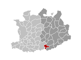
Hulshout est une commune néerlandophone de Belgique située en Région flamande dans la province d'Anvers.
Wikimedia Foundation.
2010.
Contenu soumis à la licence CC-BY-SA. Source : Article Hulshout de Wikipédia en français (auteurs)
Regardez d'autres dictionnaires:
Hulshout — Hulshout … Deutsch Wikipedia
Hulshout — Infobox Belgium Municipality name=Hulshout picture= picture map arms=Hulshout wapen.gif region=BE REG FLE community=BE NL province=BE PROV AN arrondissement=Turnhout nis=13016 pyramid date= 0 19= 20 64= 65= foreigners= foreigners date= mayor=Mark … Wikipedia
Hulshout — Original name in latin Hulshout Name in other language Hulshout State code BE Continent/City Europe/Brussels longitude 51.07451 latitude 4.79081 altitude 13 Population 9198 Date 2012 01 18 … Cities with a population over 1000 database
Hulshout — Sp Hiùlshautas Ap Hulshout flamandiškai (olandų k. tarme) L Belgija … Pasaulio vietovardžiai. Internetinė duomenų bazė
Antorf — Antwerpen … Deutsch Wikipedia
Antwerpen (Provinz) — Provinz Antwerpen Anvers (fr) Antwerpen (nl) Region: Flandern Hauptstadt: Antwerpen … Deutsch Wikipedia
BE-VAN — Provinz Antwerpen Anvers (fr) Antwerpen (nl) Region: Flandern Hauptstadt: Antwerpen … Deutsch Wikipedia
Bonheiden (Belgien) — Bonheiden … Deutsch Wikipedia
Herrschaft Mecheln — Mecheln … Deutsch Wikipedia
Liezele — Wappen Karte Wappen von Puurs Provinz Antwerpen in Belgien Puurs … Deutsch Wikipedia