Ilfracombe
- Ilfracombe
-
51° 12′ 29″ N 4° 07′ 12″ W / 51.208, -4.12
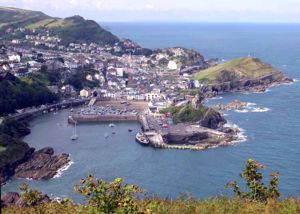
Ilfracombe vue de Hillsborough

Hillsborough (135 mètres) vue de le Port d'Ilfracombe
Ilfracombe est une station balnéaire de 11000 habitants, située sur la côte septentrionale du Devon, en Angleterre. La station est baignée par les eaux de la mer celtique, précisément par le Canal de Bristol.
A l'origine, Ilfracombe est un port de pêche, puis de commerce, qui devint une station balnéaire fréquentée grâce au transport ferroviaire au XIXe siècle.
Grâce aux aménagements de Tunnels Beaches qui bloquent le reflux de la marée, on peut pratiquer la baignade tout au long de la journée.
Le port est dominé par la colline de Hillborough qui culmine à 135 mètres de haut. Du sommet, on jouit d'un superbe panorama sur toute la côte rocheuse et escarpée.
Wikimedia Foundation.
2010.
Contenu soumis à la licence CC-BY-SA. Source : Article Ilfracombe de Wikipédia en français (auteurs)
Regardez d'autres dictionnaires:
Ilfracombe — Ilfracombe, Stadt am Kanale von Bristol in der englischen Grafschaft Devonshire; Hafen mit Leuchtthurm, Handel, Schifffahrt, Seebad; 3000 Ew … Pierer's Universal-Lexikon
Ilfracombe — (spr. illsräkūm), Stadt und Seebad im nördlichen Devonshire (England), in romantischer Lage, am Bristolkanal, mit Landungsbrücke, großen Hotels, interessanten Spazierwegen an der hügelreichen Küste und (1901) 8557 Einw … Meyers Großes Konversations-Lexikon
Ilfracombe — (spr. illfrĕkuhm), Stadt in der engl. Grafsch. Devon, (1901) 8557 E., Seebad, Hafen … Kleines Konversations-Lexikon
Ilfracombe — Infobox UK place static static image caption= Ilfracombe seen from Hillsborough country = England official name= Ilfracombe latitude= 51.2089 longitude= 4.1205 population = 10,840 (2001 parish census) [cite web|url=http://neighbourhood.statistics … Wikipedia
Ilfracombe — 51.206666666667 4.1294444444444 Koordinaten: 51° 12′ N, 4° 8′ W … Deutsch Wikipedia
Ilfracombe — Original name in latin Ilfracombe Name in other language Ilfracombe, Iltracombe State code GB Continent/City Europe/London longitude 51.2093 latitude 4.11344 altitude 14 Population 10486 Date 2013 07 05 … Cities with a population over 1000 database
Ilfracombe Urban District — Lage in Devon Status Urban District Region South West England Verw.grafschaft Devon Verwaltungssitz Ilfracombe Fläche … Deutsch Wikipedia
Ilfracombe Community Centre — is a community centre which serves the North Devon coastal town of Ilfracombe.During the early 1990s, the team of the popular English reality television show, Challenge Anneka , relocated the centre from its former base near Ilfracombe Library,… … Wikipedia
Ilfracombe Branch Line — The Ilfracombe Branch of the London South Western Railway (LSWR), ran between Barnstaple and Ilfracombe in North Devon. The branch opened as a single track line in 1874, but was sufficiently popular that it needed to be upgraded to double track… … Wikipedia
Ilfracombe Arts College — Infobox UK school name = Ilfracombe Media Arts College size = latitude = 51.20466 longitude = 4.11435 dms = dms motto = Excellence For All motto pl = established = approx = closed = c approx = type = religion = president = head label = Principal… … Wikipedia


