Ilinden

Ilinden

41° 59′ N 21° 35′ E / 41.99, 21.58

Илинден
Ilinden
Blason de ИлинденIlinden
Héraldique
Drapeau de ИлинденIlinden
Drapeau

Administration
Pays Drapeau de Macédoine Macédoine
Région Skopje
Municipalité Ilinden
Maire Stevtche Avramovski
Géographie
Coordonnées 41° 59′ Nord
       21° 35′ Est
/ 41.99, 21.58
Superficie 9 702 ha = 97,02 km2
Démographie
Population 15 894 hab. (2002)
Densité 163,8 hab./km2
Localisation
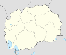
Macedonia location map.svg
City locator 14.svg
Илинден
Ilinden
Internet
Site de la ville www.ilinden.gov.mk

Ilinden (en macédonien : Илинден ; en albanais : Ilindeni) est une municipalité du nord de la République de Macédoine. Elle comptait en 2002 15 894 habitants. Ilinden est connue pour l'insurrection qui s'y déroula en partie en août 1903 et qui visait l'indépendance de la Macédoine vis-à-vis de l'Empire ottoman. Ce soulèvement s'est déroulé le jour de la Saint-Élie et cette fête a donné son nom à la municipalité ; en macédonien, Ilinden signifiant le jour d'Élie.

Ilinden est bordée par les municipalités d'Aratchinovo, Petrovets, Skopje et Koumanovo. Les Macédoniens slaves forment, avec 13 959 habitants, le premier groupe ethnique. Ils sont suivis par les Serbes, 912 habitants ; les Roms, 428 ; et les Albanais, 352.

Voir aussi


Wikimedia Foundation. 2010.

Contenu soumis à la licence CC-BY-SA. Source : Article Ilinden de Wikipédia en français (auteurs)

Игры ⚽ Поможем написать реферат

Regardez d'autres dictionnaires:

  • Ilinden — (kyrillisch Илинден, zu dt. Eliastag) bezeichnet: in Bulgarien ein Dorf, siehe Ilinden (Dorf) ein Bezirk der bulgarischen Hauptstadt Sofia, siehe Ilinden (Sofia) einen bulgarisch griechischer Grenzübergang, siehe Grenzübergang Ilinden Exochi …   Deutsch Wikipedia

  • Ilinden — (Cyrillic: Илинден, Saint Elijah s Day ) may refer to:Events*The Bulgarian and Macedonian National Holiday, celebrated on 2 August each year in commemoration of the St Elijah s Day uprising of 1903 against the Ottoman EmpireGeographic locations*… …   Wikipedia

  • Ilinden — Original name in latin Илинден Name in other language Belimbegovo, Ilinden State code MK Continent/City Europe/Skopje longitude 41.99611 latitude 21.58222 altitude 229 Population 16406 Date 2006 10 04 …   Cities with a population over 1000 database

  • Ilinden — Sp Ìlindenas Ap Илинден/Ilinden L Makedonija …   Pasaulio vietovardžiai. Internetinė duomenų bazė

  • Ilinden — Admin ASC 1 Code Orig. name Ilinden Country and Admin Code MK.36 MK …   World countries Adminstrative division ASC I-II

  • Ilinden Municipality — Општина Илинден   Rural municipality   …   Wikipedia

  • Ilinden (Dorf) — Ilinden (Илинден) Hilfe zu Wappen …   Deutsch Wikipedia

  • Ilinden Peak — (Vrah Ilinden vr h i lin den) is an ice covered peak rising to 620 m in Breznik Heights on Greenwich Island, Antarctica. Situated 1.2 km northeast of Razgrad Peak, 1.3 km east by north of Terter Peak, 700 m west of Momchil Peak, and 3.4 km… …   Wikipedia

  • Ilinden (village) — Ilinden ( mk. Илинден) is a village in Republic of Macedonia. It is a seat of the Ilinden municipality …   Wikipedia

  • Ilinden, Sofia — Ilinden ( bg. Илинден) is an urban municipality of Sofia, located in the western parts of the City. As of 2006 it has 37,256 inhabitants. There are four neighbourhoods: Zaharna Fabrika , Gevgeliiski , Sveta Troitsa (Holy Trinity) and Ilinden …   Wikipedia

Share the article and excerpts

Direct link
Do a right-click on the link above
and select “Copy Link”