- Interstate 12
-
Interstate 12 
Longueur 137,74 km (85,59 mi) Direction ouest / est Extrémité ouest  Interstate 10 à Bâton-Rouge
Intersections  Interstate 55 près de Hammond
 U.S. Route 190 près de Covington
Extrémité est  Interstate 10 et Interstate 59 près de Slidell
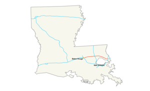
Réseau Interstate highway L'Interstate 12 (ou I-12) est une autoroute inter-états située dans l'État de Louisiane, aux États-Unis d'Amérique. Elle part de Bâton-Rouge, parcourt la côte nord du Lac Pontchartrain, et se termine à l'intersection des Interstates 10 et 59 près de Slidell.
Intersections
- Interstate 10 à Bâton-Rouge, Louisiane
- Interstate 55 à Hammond
- Interstate 10 et Interstate 59 près de Slidell, Louisiane
Voir aussi
Autoroutes inter-États (principales en rose) 
4 5 8 10 12 15 16 17 19 20 22 24 25 26 27 29 30 35 37 39 40 43 44 45 49 55 57 59 64 65 66 68 69 70 71 72 73 74 75 76 (W) 76 (E) 77 78 79 80 81 82 83 84 (W) 84 (E) 85 86 (W) 86 (E) 87 88 (W) 88 (E) 89 90 91 93 94 95 96 97 99 (238) H-1 H-2 H-3 Autres A-1 A-2 A-3 A-4 PRI-1 PRI-2 PRI-3 Catégories :- Autoroute inter-États américaine
- Route de Louisiane


Wikimedia Foundation. 2010.