- Interstate 57
-
Interstate 57 
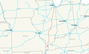
Longueur 621,40 km (386.12 mi) Direction nord / sud Extrémité sud  à Miner, MO
Intersections  I-24 à Pulleys Mill, IL
 I-64 à Mount Vernon, IL
 I-70 à Effingham, IL

 I-72/I-74 à Champaign, IL
 I-80 à Country Club Hills, IL
Extrémité nord  à Chicago, IL
Réseau Interstate highway L'Interstate 57 (I-57), est une autoroute inter-États qui commence dans le Missouri et traverse l'Illinois pour relier la ville de Miner à celle de Chicago.
Principales villes traversées
- Sikeston
- Charleston
- Cairo
- Marion
- Mount Vernon
- Effingham
- Mattoon
- Champaign
- Kankakee
- Chicago
Voir aussi
Autoroutes inter-États (principales en rose) 
4 5 8 10 12 15 16 17 19 20 22 24 25 26 27 29 30 35 37 39 40 43 44 45 49 55 57 59 64 65 66 68 69 70 71 72 73 74 75 76 (W) 76 (E) 77 78 79 80 81 82 83 84 (W) 84 (E) 85 86 (W) 86 (E) 87 88 (W) 88 (E) 89 90 91 93 94 95 96 97 99 (238) H-1 H-2 H-3 Autres A-1 A-2 A-3 A-4 PRI-1 PRI-2 PRI-3 Catégorie :- Autoroute inter-États américaine


Wikimedia Foundation. 2010.