Interstate 695 (Maryland)

Interstate 695 (Maryland)
Interstate 695
I-695.svg
I-695 in MD map.png
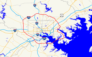
Longueur 82,82 km (51,46 mi)
Ouverture 1959
Intersections I-97.svg I-97 à Glen Burnie, MD
MD Route 295.svg B-W Parkway à Linthicum, MD
I-95.svg I-95 à Arbutus, MD
US 40.svg U.S. 40 à Catonsville, MD
I-70.svg I-70 à Woodlawn, MD
I-795.svg I-795 à Pikesville, MD
I-83.svg I-83 à Lutherville-Timonium, MD
I-95.svg I-95 à White Marsh, MD
Réseau Interstate highway

L'Interstate 695 (officiellement McKeldin Beltway, surnommée Baltimore Beltway et abrégée I-695) est une autoroute inter-États de 82,82 kilomètres de long située aux États-Unis d'Amérique. Elle est la ceinture périphérique de la ville de Baltimore (Maryland).

L'autoroute est payante par endroit comme par exemple au niveau du pont Francis Scott Key Bridge qui traverse la rivière Patapsco au niveau du port de Baltimore.

Voir aussi

Autoroutes inter-États (principales en rose) Interstate Highway marker
4 5 8 10 12 15 16 17 19 20 22 24 25 26 27 29
30 35 37 39 40 43 44 45 49 55 57 59 64 65 66 68
69 70 71 72 73 74 75 76 (W) 76 (E) 77 78 79 80 81
82 83 84 (W) 84 (E) 85 86 (W) 86 (E) 87 88 (W) 88 (E)
89 90 91 93 94 95 96 97 99 (238) H-1 H-2 H-3
Autres A-1 A-2 A-3 A-4 PRI-1 PRI-2 PRI-3


Wikimedia Foundation. 2010.

Contenu soumis à la licence CC-BY-SA. Source : Article Interstate 695 (Maryland) de Wikipédia en français (auteurs)

Игры ⚽ Нужно сделать НИР?

Regardez d'autres dictionnaires:

  • Interstate 695 (Maryland) — Interstate 695 Baltimore Beltway Route information …   Wikipedia

  • Interstate 695 — is the designation for several Interstate Highways in the United States, all of which are related to Interstate 95: *Interstate 695 (Washington, D.C.), a partially built connector in Washington, D.C. *Interstate 695 (Maryland), a beltway around… …   Wikipedia

  • Interstate 795 (Maryland) — Interstate 795 Northwest Expressway Route information …   Wikipedia

  • Interstate 795 (Maryland) — Interstate 795 Longueur 14,47 km (8,99 mi) Ouverture 1985 …   Wikipédia en Français

  • Interstate 895 (Maryland) — Interstate 895 Longueur 23,93 km (14,87 mi) Ouverture 1977 …   Wikipédia en Français

  • Interstate 695 — In den Vereinigten Staaten gibt es mehrere Interstate Highways mit der Nummer 695. Dabei handelt es sich um Ortsumgehungen und Entlastungsstrecken für den Interstate Highway 95. Dreistellige Nummern bezeichnen Autobahnringe und Zubringer zu… …   Deutsch Wikipedia

  • Interstate 895 (Maryland) — Infobox road route=895 state=MD type=I maint=MDSHA alternate name=Harbor Tunnel Thruway length mi=14.87 length round=2 length ref= [ [http://sha.state.md.us/SHAServices/trafficReports/mileage.pdf Maryland s Interstate System] as of December 31,… …   Wikipedia

  • Interstate 170 (Maryland) — Infobox road state=MD route=170 type=I maint=Baltimore Department of Public WorksMaryland State Highway Administration, PDFlink| [http://www.sha.state.md.us/KeepingCurrent/performTrafficStudies/dataAndStats/hwyLocationRef/2005 hlr all/co24.pdf… …   Wikipedia

  • Interstate 695 (Massachusetts) — Interstate 695 1955 Yellow Book plan for the Boston area showing the Inner Belt and related highways …   Wikipedia

  • Interstate 695 (Pennsylvania) — Interstate 695 Route information Maintained by PennDOT Length: 10 mi (16 km) …   Wikipedia

Share the article and excerpts

Direct link
Do a right-click on the link above
and select “Copy Link”