- Interstate 81
-
Interstate 81 
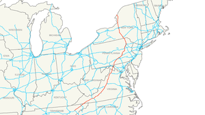
Longueur 1 361 km (846 mi) Direction nord / sud Extrémité sud  I-40 à Dandridge, TN
Intersections  I-26 à Kingsport, TN
 I-64 à Lexington, VA
 I-66 à Strasburg, VA
 I-70 à Hagerstown, MD

 I-76 à Harrisburg, PA
 I-77 à Wytheville, VA
 I-84 à Scranton, PA
 I-88 à Binghamton, NY
 I-90 à Syracuse, NY
Extrémité nord  Ont 137 près de Alexandria
(puis vers
 Ont 401)
Réseau Interstate highway L'Interstate 81 (I-81), est une autoroute inter-États de 1361 kilomètres de long située dans le nord-est des États-Unis. Elle relie la ville de Dandridge, Tennessee à la frontière entre les États-Unis et le Canada dans l'État de New York en suivant le dessin des montagnes Appalaches.
Principales villes traversées
- Dandridge
- Morristown
- Kingsport
- Bristol
- Abingdon
- Marion
- Wytheville
- Radford
- Christiansburg
- Salem près de Roanoke
- Lexington
- Staunton
- Harrisonburg
- Strasburg
- Winchester
- Martinsburg
- Hagerstown
- Chambersburg
- Carlisle
- Harrisburg
- Hazleton
- Wilkes-Barre
- Scranton
- Binghamton
- Cortland
- Syracuse
- Watertown
Voir aussi
Autoroutes inter-États (principales en rose) 
4 5 8 10 12 15 16 17 19 20 22 24 25 26 27 29 30 35 37 39 40 43 44 45 49 55 57 59 64 65 66 68 69 70 71 72 73 74 75 76 (W) 76 (E) 77 78 79 80 81 82 83 84 (W) 84 (E) 85 86 (W) 86 (E) 87 88 (W) 88 (E) 89 90 91 93 94 95 96 97 99 (238) H-1 H-2 H-3 Autres A-1 A-2 A-3 A-4 PRI-1 PRI-2 PRI-3 Catégorie :- Autoroute inter-États américaine


Wikimedia Foundation. 2010.