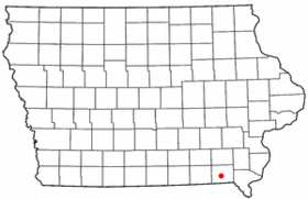
Keosauqua
Contenu soumis à la licence CC-BY-SA. Source : Article Keosauqua de Wikipédia en français (auteurs)
Regardez d'autres dictionnaires:
Keosauqua — Keosauqua, IA U.S. city in Iowa Population (2000): 1066 Housing Units (2000): 505 Land area (2000): 1.462793 sq. miles (3.788617 sq. km) Water area (2000): 0.118008 sq. miles (0.305640 sq. km) Total area (2000): 1.580801 sq. miles (4.094257 sq.… … StarDict's U.S. Gazetteer Places
Keosauqua, IA — U.S. city in Iowa Population (2000): 1066 Housing Units (2000): 505 Land area (2000): 1.462793 sq. miles (3.788617 sq. km) Water area (2000): 0.118008 sq. miles (0.305640 sq. km) Total area (2000): 1.580801 sq. miles (4.094257 sq. km) FIPS code:… … StarDict's U.S. Gazetteer Places
Keosauqua — Original name in latin Keosauqua Name in other language State code US Continent/City America/Chicago longitude 40.73031 latitude 91.96239 altitude 179 Population 1006 Date 2011 05 14 … Cities with a population over 1000 database
Keosauqua — Sp Kiosokvà Ap Keosauqua L JAV Van Bjureno apyg. c. (Ajova) … Pasaulio vietovardžiai. Internetinė duomenų bazė
Keosauqua (Iowa) — Keosauqua Ciudad de los Estados Unidos … Wikipedia Español
Keosauqua, Iowa — Infobox Settlement official name = Keosauqua, Iowa settlement type = City nickname = motto = imagesize = image caption = image imagesize = image caption = image mapsize = 250px map caption = Location of Keosauqua, Iowa mapsize1 = map caption1 =… … Wikipedia
6K9 — Keosauqua Municipal Airport, Keosauqua, Iowa USA (Regional » Airport Codes) … Abbreviations dictionary
52565 — Keosauqua, Ia (Miscellaneous » ZIP Codes) … Abbreviations dictionary
National Register of Historic Places listings in Van Buren County, Iowa — Location of Van Buren County in Iowa This is a list of the National Register of Historic Places listings in Van Buren County, Iowa. This is intended to be a complete list of the properties and districts on the National Register of Historic Places … Wikipedia
Iowa Highway 1 — Infobox road state= IA type= IOWA route= 1 alternate name= length mi= 120 length round= length ref= [http://iowahighways.home.mchsi.com/highways/iowa1 9.html#1a Iowa Highways: 1 to 9] ] established= October 16, 1926 direction a= South starting… … Wikipedia
 États-Unis
 Iowa
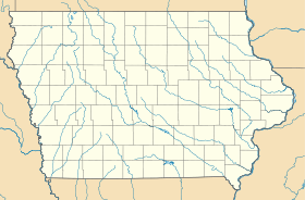
Iowa