Kistanje

Kistanje

Kistanje

Pays Drapeau de Croatie Croatie
Comitat Šibenik-Knin
Population
(municipalité)
3 038 hab. (2001)
Population
(village)
1 752 hab. (2001)
Superficie
(municipalité)
244,11 km2
Densité
(municipalité)
12,45 hab./km2
Coordonnées 43° 59′ N 15° 58′ E / 43.98, 15.9743° 59′ Nord
       15° 58′ Est
/ 43.98, 15.97
  
Indicatif téléphonique +385 022
Code postal 22 305
Maire
(načelnik)
Slobodan Rončević[1] (SDSS) 2005-2009

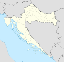
Géolocalisation sur la carte : Croatie

(Voir situation sur carte : Croatie)
Kistanje

Kistanje est un village et une municipalité située en Dalmatie, dans le comitat de Šibenik-Knin, en Croatie. Au recensement de 2001, la municipalité comptait 3 038 habitants, dont 57,14 % de Serbes et 41,31 % de Croates[2] ; le village seul comptait 1 752 habitants[3].

Sommaire

Histoire

Localités

La municipalité de Kistanje compte 14 localités :

  • Biovičino Selo
  • Đevrske
  • Gošić
  • Ivoševci
  • Kakanj
  • Kistanje
  • Kolašac
  • Krnjeuve
  • Modrino Selo
  • Nunić
  • Parčić
  • Smrdelje
  • Varivode
  • Zečevo


Notes et références

  1. (hr) Gouvernement de Croatie, « Adresse et contact de la municipalité » sur vlada.hr. Consulté le 17 janvier 2009
  2. Recensement de 2001 : (en) Population by ethnicity, by towns/municipalities, census 2001 sur dzs.hr, Crostat - Bureau central de statistiques. Consulté le 7 juillet 2008
  3. (en) Population by sex and age by settlements, census 2001 sur dzs.hr, Crostat - Bureau central de statistiques. Consulté le 7 juillet 2008

Voir aussi

Articles connexes

Liens externes


Wikimedia Foundation. 2010.

Contenu soumis à la licence CC-BY-SA. Source : Article Kistanje de Wikipédia en français (auteurs)

Игры ⚽ Нужно решить контрольную?

Regardez d'autres dictionnaires:

  • Kistanje — Kistanje …   Deutsch Wikipedia

  • Kistanje — (Serbian Cyrillic: Кистање) is a village and municipality in Šibenik Knin County, Croatia. According to the 2001 census, Kistanje municipality has 3,038 inhabitants of which 57.14% are Serbs and 41.31% are Croats.HistoryKistanje was first… …   Wikipedia

  • Kistanje — Kistanje, Marktflecken in Dalmatien, Bezirksh. Benkovac, in dem Karstgebiet Bukovica, unfern der Kerka, die hier Wasserfälle bildet, hat ein Bezirksgericht und (1900) 1876 (als Gemeinde 10,049) serbokroatische Einwohner. Östlich liegen das uralte …   Meyers Großes Konversations-Lexikon

  • Kìstānje — sr naselje u Dalmatinskoj zagori …   Veliki rječnik hrvatskoga jezika

  • Kistanje — Kìstānje sr DEFINICIJA naselje u Dalmatinskoj zagori, 2021 stan …   Hrvatski jezični portal

  • Kistanje — Original name in latin Kistanje Name in other language Chistagne, Kistanje State code HR Continent/City Europe/Zagreb longitude 43.98278 latitude 15.965 altitude 239 Population 1761 Date 2012 01 19 …   Cities with a population over 1000 database

  • Bukovica — (Буковица in Serbian) is a geographical region in Croatia. It is situated in northern Dalmatia, between Lika in the north, Kninska Krajina in the east, and Ravni Kotari in the south west. Prior to the war, it encompassed the western half of the… …   Wikipedia

  • Ivoševci — (Serbian Cyrillic: Ивошевци) is a village located in the municipality of Kistanje, in the Šibenik Knin County, Croatia. The village is situated in northern Dalmatia, in the region known as Bukovica. The population is 359 (census 2001).Family… …   Wikipedia

  • Geognostische Karte — Geologische Karte von Lothringen: eine moderne geologische Karte Eine geologische Karte stellt die geologischen Verhältnisse eines Gebietes an der Erdoberfläche oder einer zur Oberfläche parallelen Ebene in einer Karte dar. Oft wird die… …   Deutsch Wikipedia

  • Geologische Kartierung — Geologische Karte von Lothringen: eine moderne geologische Karte Eine geologische Karte stellt die geologischen Verhältnisse eines Gebietes an der Erdoberfläche oder einer zur Oberfläche parallelen Ebene in einer Karte dar. Oft wird die… …   Deutsch Wikipedia

Share the article and excerpts

Direct link
Do a right-click on the link above
and select “Copy Link”