Laarbeek
- Laarbeek
-
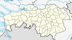
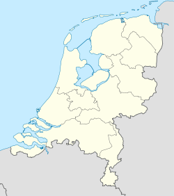
Laarbeek est une commune des Pays-Bas de la province du Brabant-Septentrional.
Localités
Aarle-Rixtel, Achterbosch, Beek en Donk, Beemdkant, Broek, Croy, De Hei, Deense Hoek, Ginderdoor, Groenewoud, Heikant, Het Hool, Het Laar, 't Hof, Kruisschot, Lieshout, Mariahout, Scheepstal, Strijp, Wolfsputten.
Lien externe
|
|
| Hameaux et autres lieux |
Achterbosch • Beemdkant • 't Broek • Croy • Deense Hoek • Ginderdoor • Groenewoud • De Hei • Heikant • 't Hof • Het Hool • Kruisschot • Het Laar • Scheepstal • Strijp • Wolfsputten |
| Pays-Bas • Brabant-Septentrional • Communes des Pays-Bas |
Wikimedia Foundation.
2010.
Contenu soumis à la licence CC-BY-SA. Source : Article Laarbeek de Wikipédia en français (auteurs)
Regardez d'autres dictionnaires:
Laarbeek — Gemeinde Laarbeek Flagge Wappen Provinz Nordbrabant Bürgermeiste … Deutsch Wikipedia
Laarbeek — Infobox Settlement official name = Laarbeek mapsize = 280px subdivision type8 = Country subdivision name = Netherlands subdivision type1 = Province subdivision name1 = North Brabant area footnotes = (2006) area total km2 = 56.17 area land km2 =… … Wikipedia
Heikant (Laarbeek) — Heikant is a hamlet in the municipality of Laarbeek, in the Dutch province of North Brabant. It is located about 3 km east of Aarle Rixtel. ANWB Topografische Atlas Nederland , Topografische Dienst and ANWB, 2005.] Heikant has a population of… … Wikipedia
Gemeente Laarbeek — Admin ASC 2 Code Orig. name Gemeente Laarbeek Country and Admin Code NL.06.1659 NL … World countries Adminstrative division ASC I-II
Mariahout — Gemeinde Laarbeek Flagge Wappen Provinz Nordbrabant … Deutsch Wikipedia
Liste der ehemaligen Gemeinden in Nordbrabant — Hierunter folgt eine Liste der ehemaligen nordbrabantischen Gemeinden. Wenn das Gebiet einer aufgehobenen Gemeinde über mehrere Gemeinden verteilt worden ist, ist das Großteil der erstgenannten Gemeinde hinzugefügt. Grenzkorrekturen zwischen… … Deutsch Wikipedia
Aarle-Rixtel — 51°30′32″N 5°38′16″E / 51.50889, 5.63778 … Wikipédia en Français
Beek en Donk — 51°32′5″N 5°37′49″E / 51.53472, 5.63028 … Wikipédia en Français
Lieshout — 51°31′10″N 5°35′38″E / 51.51944, 5.59389 … Wikipédia en Français
Mariahout — 51°32′20″N 5°34′2″E / 51.53889, 5.56722 … Wikipédia en Français


 Pays-Bas