Lambertschaag
Contenu soumis à la licence CC-BY-SA. Source : Article Lambertschaag de Wikipédia en français (auteurs)
Regardez d'autres dictionnaires:
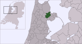
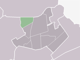
Lambertschaag — Dutch town locator maps mun town caption = The statistical district (light green) of Lambertschaag in the municipality of Noorder Koggenland.Lambertschaag (coord|52|45|N|5|1|E|type:city(190)) is a town in the Dutch province of North Holland. It… … Wikipedia
Abbekerk — 52° 44′ 00″ N 5° 01′ 00″ E / 52.7333, 5.01667 … Wikipédia en Français
Noorder-Koggenland — Coat of arms … Wikipedia
List of places in the Netherlands — This is an alphabetical list of places (cities, towns, villages) in the Netherlands. Lists per province can be found at:* List of towns in Groningen * List of towns in Friesland * List of towns in Drente * List of towns in Overijssel * List of… … Wikipedia
Steamtrain Hoorn Medemblik — Station Hoorn The Museumstoomtram Hoorn Medemblik is a heritage railway in the Netherlands. It runs from Hoorn to Medemblik, a distance of about 20km. Contents 1 … Wikipedia
Noorder-Koggenland — Gemeinde Noorder Koggenland Flagge Wappen Provinz Nordholland … Deutsch Wikipedia
Andijk — 52°44′0″N 5°13′0″E / 52.73333, 5.21667 … Wikipédia en Français
Benningbroek — 52° 42′ 11″ N 5° 00′ 35″ E / 52.7031, 5.00972 … Wikipédia en Français
Hauwert — 52° 43′ 00″ N 5° 06′ 00″ E / 52.7167, 5.1 … Wikipédia en Français
Liste des localités des Pays-Bas par code postal — Cette page est une liste des localités (villes, villages) des Pays Bas par code postal. Les localités ne possédant pas leur propre code postal ne figurent pas dans cette liste. Sommaire 1 1000 1999 1.1 1000 1099 1.2 1100 1199 … Wikipédia en Français