Latitude World Square
- Latitude World Square
-
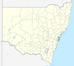
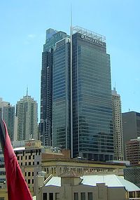
Le Latitude World Square est un gratte-ciel de bureaux appartenant à la société Ernst & Young, construit à Sydney (Australie) en 2004, et situé au 688 George Street, à l'angle avec Goulburn Street.
Liens externes
Catégories :
- Gratte-ciel de Sydney
- Gratte-ciel mesurant entre 200 et 249 mètres
- Gratte-ciel construit en 2004
Wikimedia Foundation.
2010.
Contenu soumis à la licence CC-BY-SA. Source : Article Latitude World Square de Wikipédia en français (auteurs)
Regardez d'autres dictionnaires:
Latitude (building) — Latitude is part of the World Square complex bounded by George, Goulburn, Liverpool and Pitt Streets in Sydney, Australia. The building s official name is Ernst Young Tower at Latitude and is located on the corner of George and Goulburn… … Wikipedia
World Meteorological Organization squares — or WMO squares is a system of geocodes that divides a chart of the world with latitude longitude gridlines (e.g. plate carrée projection, Mercator or other) into grid cells of 10° latitude by 10° longitude, each with a unique, 4 digit numeric… … Wikipedia
World War II — the war between the Axis and the Allies, beginning on September 1, 1939, with the German invasion of Poland and ending with the surrender of Germany on May 8, 1945, and of Japan on August 14, 1945. Abbr.: WWII * * * or Second World War (1939–45)… … Universalium
World energy resources and consumption — In order to directly compare world energy resources and consumption of energy, this article uses SI units and prefixes and measures energy rate (or power) in watts (W) and amounts of energy in joules (J). One watt is one joule per second. In 2005 … Wikipedia
Circle of latitude — Map of Earth Longitude (λ) Lines of longitude appear vertical with varying curvature in this projection, but are actually halves of great ellipses, with identical radii at a given latitude. Latitude (φ) Lines of latitude appear … Wikipedia
Marsden square — A Marsden Square map Marsden square mapping or Marsden squares is a system that divides a chart of the world with latitude longitude gridlines (e.g. plate carrée projection, Mercator or other) between 80°N and 70°S latitudes (or 90°N and 80°S:… … Wikipedia
Maritime Square — For the location formerly known as Maritime Square in Singapore, see HarbourFront. Maritime Square Maritime Square Entrance After renovation Location Tsing Yi Island, Hong Kong … Wikipedia
Early world maps — Ptolemy s world map (2nd century) in a 15th century reconstruction Early world maps cover depictions of the world from the Iron Age to the Age of Discovery and the emergence of modern geography during the early modern period … Wikipedia
Walt Disney World Resort — Not to be confused with Disneyland. Coordinates: 28°25′7″N 81°34′52″W / 28.41861°N 81.58111°W / 28.41861; 81.5 … Wikipedia
The Venue Leicester Square — Infobox Theatre name = Leicester Square Theatre caption = Fill image address = Leicester Square city = Westminster, London country = designation = latitude = 51.510278 longitude = 0.130278 architect = owner = The Venue Group capacity = type =… … Wikipedia
 Australie