- Sint-Amands
-
Saint-Amand (Anvers)
 Pour les articles homonymes, voir Saint-Amand.
Saint-Amand
(nl) Sint-Amands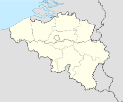

Géographie Pays  Belgique
Région  Région flamande
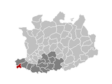
Communauté Communauté flamandeProvince  Province d'Anvers
Arrondissement Malines Coordonnées Superficie
– Surface agricole
– Bois
– Terrains bâtis
– Divers15,58 km² (2005)
64,99 %
7,22 %
25,41 %
2,39 %Données sociologiques (source : statbel.fgov.be) Population
– Hommes
– Femmes
Densité7.887 (1er janvier 2008)
49,41 %
50,59 %
506 hab./km²Pyramide des âges
– 0–17 ans
– 18–64 ans
– 65 ans et +(1er janvier 2008)
20,86 %
60,80 %
18,35 %Étrangers 2,21 % (1er janvier 2008) Économie Taux de chômage 4,68 % (janvier 2009) Revenu annuel moyen 15.048 €/hab. (2005) Politique Bourgmestre Karel De Smedt (CD&V) Majorité CD&V, L.O.S. Sièges
CD&V
L.O.S.
VLD
sp.a21
9
4
3
3
1
1Sections de commune Section Code postal Sint-Amands
Lippelo
Oppuurs2890
2890
2890Autres informations Gentilé (inconnu) Zone téléphonique 03 - 052 Code INS 12034 Site officiel www.sint-amands.be Saint-Amand (en néerlandais et nom officiel Sint-Amands) est une commune néerlandophone de Belgique située en Région flamande dans la province d'Anvers.
On utilise également Saint-Amand-lez-Puers pour désigner la commune en français et dans d'autres langues, mais son usage est vieilli.
Géographie
Altitude moyenne : 7 mètres.
Terrain plat, sol argilo-sableux.
Célébrités
- Lieu de naissance d'Emmanuel Rollier (1769-1851), meneur de la Guerre des Paysans (1798)
- Lieu de naissance et de sépulture du poète Émile Verhaeren (1855-1916)
- Lieu de naissance, de vie, de décès et de sépulture du peintre Romain De Saegher (1907-1986)
 Portail de la Belgique
Catégorie : Commune de la province d'Anvers


Wikimedia Foundation. 2010.