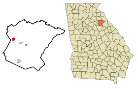
Arnoldsville
Contenu soumis à la licence CC-BY-SA. Source : Article Arnoldsville de Wikipédia en français (auteurs)
Regardez d'autres dictionnaires:
Arnoldsville — Arnoldsville, GA U.S. city in Georgia Population (2000): 312 Housing Units (2000): 136 Land area (2000): 1.680386 sq. miles (4.352180 sq. km) Water area (2000): 0.000000 sq. miles (0.000000 sq. km) Total area (2000): 1.680386 sq. miles (4.352180… … StarDict's U.S. Gazetteer Places
Arnoldsville, GA — U.S. city in Georgia Population (2000): 312 Housing Units (2000): 136 Land area (2000): 1.680386 sq. miles (4.352180 sq. km) Water area (2000): 0.000000 sq. miles (0.000000 sq. km) Total area (2000): 1.680386 sq. miles (4.352180 sq. km) FIPS code … StarDict's U.S. Gazetteer Places
Arnoldsville, Georgia — Infobox Settlement official name = Arnoldsville, Georgia other name = native name = nickname = settlement type = City motto = imagesize = image caption = flag size = image seal size = image shield = shield size = image blank emblem = blank emblem … Wikipedia
30619 — Arnoldsville, Ga (Miscellaneous » ZIP Codes) … Abbreviations dictionary
Oglethorpe County, Georgia — Location in the state of Georgia … Wikipedia
Crawford, Georgia — City Location in … Wikipedia
Maxeys, Georgia — Town Location in … Wikipedia
List of cities in Georgia, U.S. — This is a list of cities and mere towns in the American state of Georgia, U.S.A., arranged in alphabetical order.: For other towns and villages, see: List of towns and villages in Georgia (U.S. state) CompactTOC2 NOTOC… … Wikipedia
Georgia (U.S. state) locations by per capita income — Georgia is the tenth richest state in the United States of America, with a per capita income of $40,155 (2005). Georgia Places Ranked by Per Capita Income # Skidaway Island, Georgia ndash; $63,851 # Vernonburg, Georgia ndash; $49,391 # Daisy,… … Wikipedia
Athens-Clarke County metropolitan area — | accessdate = 2008 03 28] Counties*Clarke *Madison *Oconee *OglethorpeCommunities*Places with more than 100,000 inhabitants **Athens Clarke County (balance) – Principal city*Places with 1,000 to 5,000 inhabitants **Bogart **Comer **Watkinsville… … Wikipedia
 États-Unis
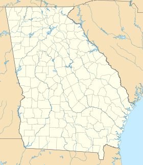
 Géorgie