- Blacksher (Alabama)
-
Blacksher Administration Pays  États-Unis
État  Alabama
Comté Baldwin GNIS 0156071 Indicatif téléphonique local 251 Démographie Population Géographie Coordonnées Altitude 43 m Superficie Fuseau horaire CST (UTC-6) 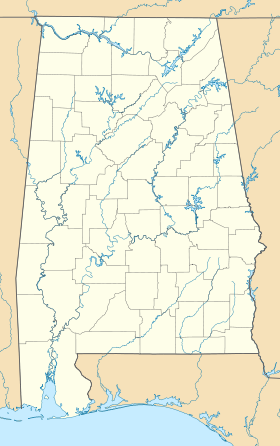


Blacksher est une communauté non-incorporée du comté de Baldwin (Alabama).
Elle fait partie de l'aire micropolitaine de Daphne–Fairhope–Foley.
Sommaire
Géographie
La communauté se trouve à une altitude moyenne de 43 mètres[1].
Climat
Relevé météorologique de la station la plus proche de Blacksher mois jan. fév. mar. avr. mai jui. jui. aoû. sep. oct. nov. déc. Température minimale moyenne (°C) 2 4 8 11 16 19 21 21 19 13 8 4 Température maximale moyenne (°C) 15 17 21 25 29 32 33 33 31 26 21 17 Précipitations (mm) 173,0 140,7 171,5 116,6 154,9 117,3 193,3 142,0 104,9 68,1 131,3 125,2 Record de froid (°C)
(année du record)-17,2
(21/01/1985)-12,2
(03/02/1951)-6,1
(01/03/2002)-1,7
(04/04/1987)5,0
(13/05/1960)9,4
(01/06/1984)16,7
(01/07/1958)13,3
(14/08/2004)5,6
(30/09/1949)-1,1
(31/10/1954)-8,3
(25/11/1950)-14,4
(13/12/1962)Record de chaleur (°C)
(année du record)28,9
(12/01/1949)29,4
(10/02/1959)30,6
(30/03/2007)35,0
(19/04/2006)38,3
(28/05/1953)40,0
(29/06/1954)40,6
(24/07/1952)40,0
(30/08/1954)38,3
(08/09/1954)36,7
(06/10/1954)32,2
(18/11/1958)29,4
(05/12/1958)Source : Yahoo! MétéoSources
Références
Compléments
Liens externes


Wikimedia Foundation. 2010.