Herceghalom
- Herceghalom
-
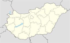
Herceghalom est un village et une commune du comitat de Pest en Hongrie.
Géographie
Cette section est vide, insuffisamment détaillée ou incomplète.
Votre aide est la bienvenue !
Histoire
Cette section est vide, insuffisamment détaillée ou incomplète.
Votre aide est la bienvenue !
Catégorie :
- Ville et village du comitat de Pest
Wikimedia Foundation.
2010.
Contenu soumis à la licence CC-BY-SA. Source : Article Herceghalom de Wikipédia en français (auteurs)
Regardez d'autres dictionnaires:
Herceghalom — is a village in Pest county, Budapest metropolitan area, Hungary. It has a population of 3,511 (2007) … Wikipedia
Pest County — Infobox Hungarian county name =Pest region =Central Hungary seat = Budapest area = 6394 population = 1,077,300 density = 168 cities = 186Pest County (IPA2|pɛʃt) is a county ( megye ) in central Hungary. It covers an area of 6394 km², and has a… … Wikipedia
Örkény — If you are looking for István Örkény, the writer, click the link. Örkény Aerialphotography: Örkény, palace … Wikipedia
Dabas, Hungary — Dabas Dabas church from the air … Wikipedia
Monor — For the commune in Bistriţa Năsăud County, Romania, see Monor, Bistriţa Năsăud. Monor Aerial photograph of Monor … Wikipedia
List of rail accidents (pre-1950) — For a list of 1950 1999 rail accidents, see List of 1950 1999 rail accidents.For a list of post 2000 rail accidents, see List of rail accidents. notoc Pre 1830 1815 * 1815, exact date unclear ndash; Philadelphia, Co Durham, England: 16 people,… … Wikipedia
Nagymaros — Aerial view … Wikipedia
Dunakeszi — City … Wikipedia
Nagykőrös — Nagykőrös … Wikipedia
Százhalombatta — Százhalombatta … Wikipedia


 Hongrie

 Herceghalom


