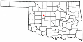
Watonga
Contenu soumis à la licence CC-BY-SA. Source : Article Watonga de Wikipédia en français (auteurs)
Regardez d'autres dictionnaires:
Watonga — Watonga, OK U.S. city in Oklahoma Population (2000): 4658 Housing Units (2000): 1507 Land area (2000): 2.735073 sq. miles (7.083806 sq. km) Water area (2000): 0.000000 sq. miles (0.000000 sq. km) Total area (2000): 2.735073 sq. miles (7.083806 sq … StarDict's U.S. Gazetteer Places
Watonga, OK — U.S. city in Oklahoma Population (2000): 4658 Housing Units (2000): 1507 Land area (2000): 2.735073 sq. miles (7.083806 sq. km) Water area (2000): 0.000000 sq. miles (0.000000 sq. km) Total area (2000): 2.735073 sq. miles (7.083806 sq. km) FIPS… … StarDict's U.S. Gazetteer Places
Watonga — Original name in latin Watonga Name in other language State code US Continent/City America/Chicago longitude 35.84477 latitude 98.41313 altitude 466 Population 5111 Date 2011 05 14 … Cities with a population over 1000 database
Watonga — Sp Vatònga Ap Watonga L JAV Bleino apyg. c. (Oklahoma) … Pasaulio vietovardžiai. Internetinė duomenų bazė
Watonga (Oklahoma) — Watonga Ciudad de los Estados Unidos Ubicación en el condado de Blaine … Wikipedia Español
Watonga, Oklahoma — Infobox Settlement official name = Watonga, Oklahoma settlement type = City nickname = motto = imagesize = image caption = image mapsize = 250px map caption = Location of Watonga, Oklahoma mapsize1 = map caption1 = subdivision type = Country… … Wikipedia
73772 — Watonga, Ok (Miscellaneous » ZIP Codes) … Abbreviations dictionary
National Register of Historic Places listings in Blaine County, Oklahoma — Location of Blaine County in Oklahoma This is a list of the National Register of Historic Places listings in Blaine County, Oklahoma. This is intended to be a complete list of the properties on the National Register of Historic Places in Blaine… … Wikipedia
David Pendleton Oakerhater — Oakerhater in 1881 Deacon and Missionary Born ca. 1847 Indian Territory Died … Wikipedia
David Pendleton Oakerhater — Oakerhater oder O kuh ha tuh (Sonnentänzer), 1881 David Pendleton Oakerhater, ursprünglich Okuhhatuh (Sonnentänzer auf Cheyenne) und Making Medicine (Name in der Gefangenschaft), (* um 1847 in Durwood; † 31. August 1931) war ein Cheyenne Krieger… … Deutsch Wikipedia
 États-Unis
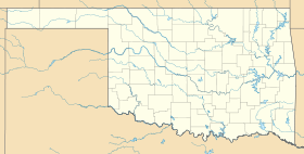
 Oklahoma