- Hertsa
-
Hertsa Герца 
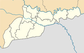
Géolocalisation sur la carte : Oblast de Tchernivtsi

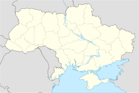
Géolocalisation sur la carte : Ukraine
Coordonnées : Pays  Ukraine
Subdivision  Oblast de Tchernivtsi
Raïon Hertsa Fondation 1437 Statut Ville depuis 1884 Population  2 130 hab. (2011)
Densité 958 hab./km² Altitude 160 m Superficie 2,223 km2 Indicatif tél. +380 3740 Code postal 60500 Liste des villes d'Ukraine | Carte Hertsa (en (ukrainien : Герца) ou Guertsa (russe : Герца ; en roumain : Herţa) est une ville de l'oblast de Tchernivtsi, en Ukraine, et le centre administratif du raïon de Hertsa. Sa population s'élevait à 2 130 habitants en 2011.
Sommaire
Géographie
Hertsa est située au sud de la rivière Prout, à 30 km au sud-est de Tchernivtsi, près de la frontière roumaine.
Histoire
Hertsa est mentionnée pour la première fois en 1437 et appartient historiquement à la principauté de Moldavie. Grâce à ses relations commerciales, la ville se développe, devient un important marché et obtient le statut de ville en 1672. Après l'occupation autrichienne de 1775-1777, la ville retourne à l'Empire ottoman. Hertsa fait partie de la Roumanie, depuis sa naissance, en 1859. Son statut de ville est renouvelé en 1864.
Après la Première Guerre mondiale, Hertsa reste une ville roumaine jusqu'à l'annexion de la Bessarabie par l'Union soviétique, le 2 août 1940. Elle est à nouveau roumaine de 1941 à 1944, avant d'être rattachée à la République socialiste soviétique d'Ukraine. Depuis 1991, elle fait partie de l'Ukraine indépendante.
Située à la frontière avec la Roumanie, la ville de Hertsa est peuplée à 95 pour cent par une population d'origine roumaine. En Roumanie même, l'annexion de la ville par l'URSS, en 1940, demeure un sujet sensible.
Population
Recensements (*) ou estimations de la population [1] :
Évolution démographique 1959* 1970* 1979* 1989* 2001* 2008 2009 2010 2011 1 407 2 094 2 149 2 360 2 068 2 098 2 109 2 127 2 130 Notes et références
- (ru) Recensements de 1959, 1970 et 1979 sur www.webgeo.ru — (en) World Gazetteer [1] — (uk) Office des statistiques d'Ukraine : Статистичний збірник «Чисельність наявного населення України на 1 січня 2008 року» [Manuel statistique « Nombre d'habitants de l'Ukraine au 1er janvier 2008 »]. [2] ; Статистичний збірник «Чисельність наявного населення України на 1 січня 2010 року» [Manuel statistique « Nombre d'habitants de l'Ukraine au 1er janvier 2010 »]. [3] ; Статистичний збірник «Чисельність наявного населення України на 1 січня 2011 року» [Manuel statistique « Nombre d'habitants de l'Ukraine au 1er janvier 2011 »]. [4]
Liens externes
- (uk) Informations officielles
- (ru) Cartes topographiques
- (en) Héraldique ukrainienne
Catégories :- Ville d'Ukraine
- Ville de l'oblast de Tchernivtsi


Wikimedia Foundation. 2010.