District de Kapurthala
- District de Kapurthala
-
District de Kapurthala
(ਕਪੂਰਥਲਾ ਜ਼ਿਲਾ) |
 |
|
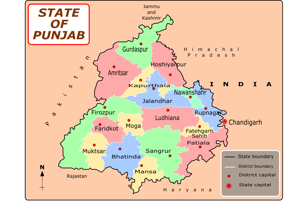
Localisation sur la carte du Penjab
|
| Administration |
| Pays |
 Inde Inde |
| Type |
District |
| État |
Penjab |
| Chef-Lieu |
Kapurthala |
| Géographie |
| Superficie |
1 646 km2 |
| Population |
| Population |
752 287 hab. (2001) |
| Densité |
457 hab./km2 |
Le District de Kapurthala est un des 22 districts de l'état indien du Penjab.
Lien externe
Site officiel
Wikimedia Foundation.
2010.
Contenu soumis à la licence CC-BY-SA. Source : Article District de Kapurthala de Wikipédia en français (auteurs)
Regardez d'autres dictionnaires:
Kapurthala district — is a district of Punjab state in northern India. The city of Kapurthala is the district headquarters.Kapurthala District is one of the smallest districts of Punjab in terms of both area and population, with 754,521 people by the 2001 census. The… … Wikipedia
Kapurthala — Ajouter une image Administration Pays Inde État et territoire Penjab District … Wikipédia en Français
Kapurthala — Infobox Indian Jurisdiction native name=Kapurthala locator position=right latd = 31.38|longd=75.38 state name = Punjab district=Kapurthala altitude=225 population as of = 2001| population total = 84361| area magnitude= area total= 909.09 area… … Wikipedia
Domeli, Kapurthala — Domeli village Coordinates Country India State Punjab … Wikipedia
Shahid Bhagat Singh Nagar district — Shahid Bhagat Singh Nagar district … Wikipedia
Mansa district, Punjab — This article is about the district. For its eponymous headquarters, see Mansa, Punjab. Mansa district … Wikipedia
Moga district — This article is about the district. For its eponymous headquarters, see Moga, Punjab. Districts of Punjab along with their headquarters Moga district (Doabi:ਮੋਗਾ ਜ਼ਿਲਾ) is one of the Twenty districts in the state of Punjab in North West Republic… … Wikipedia
Mohali district — Sahibzada Ajit Singh Nagar district … Wikipedia
Firozpur district — Ferozepur district is one of the twenty districts in the state of Punjab in North West India.It comprises an area of 11,142 km². The surface is level, with the exception of a few sand hills in the south and south east. The country consists of two … Wikipedia
Hoshiarpur district — ( pa. ਹੁਸ਼ਿਆਰਪੁਰ ਜਿਲ੍ਹਾ) is a district of Punjab state in northern India.The district has an area of 3,365 km² and a population of 14,78,045 (2001 census); Hoshiarpur is the district capital. The district is bounded by Kapurthala, Jalandhar and… … Wikipedia