Parchovany

Parchovany
Parchovany
(Village)
Administration
Pays Drapeau de Slovaquie Slovaquie
Région Région de Košice
District District de Trebišov
Code postal 076 62
Plaque minéralogique TV
Starosta (maire) Ján Hvozdík ( SMER,ĽS-HZDS )

Mandat: 2013

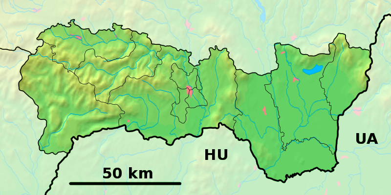
Démographie
Population 1 938 hab. (31.12.2007)
Densité 83,4 hab./km2
Géographie
Coordonnées 48° 45′ 00″ Nord
       21° 42′ 50″ Est
/ 48.75, 21.713889
Altitude 111 m
Superficie 2 322,5 ha = 23,225 km²
Localisation en Slovaquie
Voir la carte physique
Localisation de la ville
Parchovany
Voir la carte administrative
Localisation de la ville
Parchovany
Localisation dans la région de Košice
Voir la carte physique
Localisation de la ville
Parchovany
Voir la carte administrative
Localisation de la ville
Parchovany
Internet
Site de la commune http://www.parchovany.sk
Sources
Resultat des élections
http://www.e-obce.sk [1]
http://www.statistics.sk [2]

Parchovany est un village de Slovaquie situé dans la région de Košice.

Sommaire

Géographie

hydrographie

Localisation sur la rivière Topľá en aval de Vranov nad Topľou.

transport

Le village se situe sur la ligne de chemin de fer entre Sečovce à Vranov nad Topľou.

Histoire

Première mention écrite du village en 1320.

Notes et références


Wikimedia Foundation. 2010.

Contenu soumis à la licence CC-BY-SA. Source : Article Parchovany de Wikipédia en français (auteurs)

Игры ⚽ Поможем написать курсовую

Regardez d'autres dictionnaires:

  • Parchovany — is a village and municipality in the Trebišov District in the Košice Region of south eastern Slovakia.HistoryIn historical records the village was first mentioned in 1320.GeographyThe village lies at an altitude of 115 metres and covers an area… …   Wikipedia

  • Parchovany — Sp Párchovanai Ap Parchovany L Slovakija …   Pasaulio vietovardžiai. Internetinė duomenų bazė

  • Trebišov District —   District   Country Slovakia Region …   Wikipedia

  • Topľa — Vorlage:Infobox Fluss/KARTE fehlt DatenVorlage:Infobox Fluss/GKZ feh …   Deutsch Wikipedia

  • District de Trebišov — Trebišov Informations Pays …   Wikipédia en Français

  • Košice Region — Geobox | Region name = Košice other name = category = Region image caption = image caption = symbol = symbol type = Coat of arms etymology = official name = motto = nickname = country = Slovakia country state = region = district = commune =… …   Wikipedia

  • Dargov — Coordinates: 48°44′N 21°35′E / 48.733°N 21.583°E / 48.733; 21.583 …   Wikipedia

  • List of municipalities and towns in Slovakia — Slovakia This is a comprehensive list of municipalities and towns in Slovakia. For lists of towns and municipalities sorted by Regions see the individual articles on Regions. For an outdated list of towns only in Slovakia see also List of towns… …   Wikipedia

  • Cejkov — Location of Trebišov District in the Region Cejkov (Hungarian: Céke) is a village and municipality in the Trebišov District in the Košice Region of eastern Slovakia. Con …   Wikipedia

  • Zemplínske Jastrabie — Location of Trebišov District in the Region Zemplínske Jastrabie (Hungarian: Magyarsas) is a village and municipality in the Trebišov District in the Košice Region of eastern Slovakia …   Wikipedia

Share the article and excerpts

Direct link
Do a right-click on the link above
and select “Copy Link”