Svätuše

Svätuše
Svätuše
(Village)
Administration
Pays Drapeau de Slovaquie Slovaquie
Région Région de Košice
District District de Trebišov
Code postal 076 83
Plaque minéralogique TV
Starosta (maire) Gustáv Liszkai ( MOST - HÍD,SMK-MKP )

Mandat: 2013

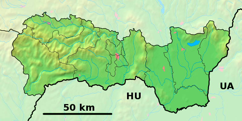
Démographie
Population 885 hab. (31.12.2007)
Densité 87,1 hab./km2
Géographie
Coordonnées 48° 26′ 00″ Nord
       21° 55′ 00″ Est
/ 48.433333, 21.916667
Altitude 98 m
Superficie 1 015,7 ha = 10,157 km²
Localisation en Slovaquie
Voir la carte physique
Localisation de la ville
Svätuše
Voir la carte administrative
Localisation de la ville
Svätuše
Localisation dans la région de Košice
Voir la carte physique
Localisation de la ville
Svätuše
Voir la carte administrative
Localisation de la ville
Svätuše
Sources
Resultat des élections
http://www.e-obce.sk [1]
http://www.statistics.sk [2]

Svätuše est un village de Slovaquie situé dans la région de Košice.

Histoire

Première mention écrite du village en 1245.

La localité fut annexée par la Hongrie après le premier arbitrage de Vienne le 2 novembre 1938. En 1938, on comptait 1114 habitants dont 103 d'origines juives. Elle faisait partie du district de Medzibodrožie (hongrois : Bodrogközi járás). Le nom de la localité avant la Seconde Guerre mondiale était Szentes. Durant la période 1938 - 1944, le nom hongrois Bodrogszentes était d'usage[3]. À la libération, la commune a été réintégré dans la Tchécoslovaquie reconstituée.

Notes et références


Wikimedia Foundation. 2010.

Contenu soumis à la licence CC-BY-SA. Source : Article Svätuše de Wikipédia en français (auteurs)

Игры ⚽ Нужно сделать НИР?

Regardez d'autres dictionnaires:

  • Svätuše — ( hu. Bodrogszentes) is a village and municipality in the Trebišov District in the Košice Region of south eastern Slovakia.HistoryIn historical records the village was first mentioned in 1245.GeographyThe village lies at an altitude of 120 metres …   Wikipedia

  • Trebišov District —   District   Country Slovakia Region …   Wikipedia

  • District de Trebišov — Trebišov Informations Pays …   Wikipédia en Français

  • Košice Region — Geobox | Region name = Košice other name = category = Region image caption = image caption = symbol = symbol type = Coat of arms etymology = official name = motto = nickname = country = Slovakia country state = region = district = commune =… …   Wikipedia

  • Dargov — Coordinates: 48°44′N 21°35′E / 48.733°N 21.583°E / 48.733; 21.583 …   Wikipedia

  • List of municipalities and towns in Slovakia — Slovakia This is a comprehensive list of municipalities and towns in Slovakia. For lists of towns and municipalities sorted by Regions see the individual articles on Regions. For an outdated list of towns only in Slovakia see also List of towns… …   Wikipedia

  • Cejkov — Location of Trebišov District in the Region Cejkov (Hungarian: Céke) is a village and municipality in the Trebišov District in the Košice Region of eastern Slovakia. Con …   Wikipedia

  • Zemplínske Jastrabie — Location of Trebišov District in the Region Zemplínske Jastrabie (Hungarian: Magyarsas) is a village and municipality in the Trebišov District in the Košice Region of eastern Slovakia …   Wikipedia

  • Dvorianky — Location of Trebišov District in the Region Dvorianky (Hungarian: Szécsudvar) is a village and municipality in the Trebišov District in the Košice Region of eastern Slovakia …   Wikipedia

  • Čeľovce — Location of Trebišov District in the Region Čeľovce (Hungarian: Cselej) is a village and municipality in the Trebišov District in the Košice Region of eastern Slovakia …   Wikipedia

Share the article and excerpts

Direct link
Do a right-click on the link above
and select “Copy Link”