Petőfibánya
- Petőfibánya
-
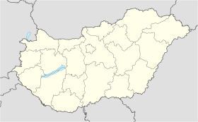
Petőfibánya est un village et une commune du comitat de Heves en Hongrie.
Géographie
Cette section est vide, insuffisamment détaillée ou incomplète.
Votre aide est la bienvenue !
Histoire
Cette section est vide, insuffisamment détaillée ou incomplète.
Votre aide est la bienvenue !
Catégorie :
- Ville et village du comitat de Heves
Wikimedia Foundation.
2010.
Contenu soumis à la licence CC-BY-SA. Source : Article Petőfibánya de Wikipédia en français (auteurs)
Regardez d'autres dictionnaires:
Petőfibánya — (formerly Pernyepuszta, Pernyebánya) is a village in Hungary, Heves county, near Hatvan. It has a population of 3118 (2002).GeographyPetőfibánya is situated 15 km from Hatvan, in the Mátraalja microregion, among the foothills of the Mátra… … Wikipedia
Petofibanya — Original name in latin Petfibnya Name in other language Petofi Banyatelep, Petofibanya, Petfi Bnyatelep, Petfibnya State code HU Continent/City Europe/Budapest longitude 47.77942 latitude 19.7055 altitude 223 Population 3061 Date 2012 01 18 … Cities with a population over 1000 database
List of planned cities — This is a list of planned cities (sometimes known as planned communities or new towns) by country. Additions to this list should be cities whose overall form (as opposed to individual neighborhoods or expansions) has been determined in large part … Wikipedia
List of places named after people — There are a number of places named after famous people. For more on the general etymology of place names see toponomy. For other lists of eponyms (names derived from people) see eponym.Continents*Americas (North America and South America) ndash;… … Wikipedia
List of city name changes — This is a list of cities which changed their name over the course of history. see also: Names of European cities in different languages.AFG*Bactra → BalkhDZA*Ikosium → Icosium → Algiers *Géryville → El Bayadh *Cirta → Constantine *Hippo Regius →… … Wikipedia
Heves County — Infobox Hungarian county name =Heves region =Northern Hungary seat = Eger area = 3637 population = 328,000 density = 90.1 cities = 119 This article is about the current administrative entity called Heves county. For the historical county see… … Wikipedia
Mónosbél — Municipality … Wikipedia
List of places in Hungary whose names were changed — A list of settlements in Hungary whose name was changed during the 19 20th century. This list contains only settlements within the present day borders of Hungary.{| class= wikitable bgcolor=#cccccc! Original name !! New name !! Period… … Wikipedia
Kleingebiet Hatvan — Das Kleingebiet Hatvan (ungarisch hatvani kistérség) ist eine ungarische Verwaltungseinheit (LAU 1) innerhalb des Komitats Heves. Der Verwaltungssitz ist in Hatvan. Gemeinden Apc Boldog Csány Ecséd Hatvan Heréd Hort Kerekharaszt Lőrinci… … Deutsch Wikipedia
Eger (Hongrie) — Pour les articles homonymes, voir Eger. Eger Héraldique … Wikipédia en Français


 Hongrie

 Petőfibánya


