Tarnaszentmária
- Tarnaszentmária
-
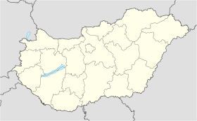
Tarnaszentmária est un village et une commune du comitat de Heves en Hongrie.
Géographie
Cette section est vide, insuffisamment détaillée ou incomplète.
Votre aide est la bienvenue !
Histoire
Cette section est vide, insuffisamment détaillée ou incomplète.
Votre aide est la bienvenue !
Catégorie :
- Ville et village du comitat de Heves
Wikimedia Foundation.
2010.
Contenu soumis à la licence CC-BY-SA. Source : Article Tarnaszentmária de Wikipédia en français (auteurs)
Regardez d'autres dictionnaires:
Tarnaszentmária — is a village at the foot of the Mátra Mountains in Hungary. ightseeingsTarnaszentmária is the village in Hungary where one of the oldest church can be found. It was founded by the Genera Aba, who were in family relations with the Árpád house… … Wikipedia
Rotunda (architecture) — A rotunda is any building with a circular ground plan, often covered by a dome. It can also refer to a round room within a building (a famous example being within the United States Capitol in Washington, D.C.). The Pantheon in Rome is a famous… … Wikipedia
Heves County — Infobox Hungarian county name =Heves region =Northern Hungary seat = Eger area = 3637 population = 328,000 density = 90.1 cities = 119 This article is about the current administrative entity called Heves county. For the historical county see… … Wikipedia
Mónosbél — Municipality … Wikipedia
Hungarian art — Magyar (Hungarian) art stems from the times of the conquest of people of Árpád in the 9th Century. A. D. Princeps Árpád organized earlier people settled in the Carpathian basin. Cavalry people in the Carpathian basinBefore Árpád’s arrival several … Wikipedia
Kleingebiet Eger — Das Kleingebiet Eger (ungarisch egri kistérség) innerhalb des Komitats Heves. Der Verwaltungssitz ist in Eger. Gemeinden Andornaktálya Demjén Eger Egerbakta Egerszalók Egerszólát Feldebrő Felsőtárkány Kerecsend Maklár Nagytálya Noszvaj … Deutsch Wikipedia
Mátra — dep1p1f1dep2p5 Mátra Höchster Gipfel Kékes (1015 m) p2 Lage Komitat Heves, Nördliches Ungarn ca. 60 km östlich der Donau … Deutsch Wikipedia
Mátra-Gebirge — dep1f1dep2p5 Mátra Karte des Mátra Gebirges Höchster Gipfel Kékes (1015 m) … Deutsch Wikipedia
Mátragebirge — dep1p1f1dep2p5 Mátra Höchster Gipfel Kékes (1015 m) p2 Lage Komitat Heves, Nördliches Ungarn ca. 60 km östlich der Donau … Deutsch Wikipedia
Eger (Hongrie) — Pour les articles homonymes, voir Eger. Eger Héraldique … Wikipédia en Français


 Hongrie

 Tarnaszentmária


